IMAGES TAKEN NEAR TO
Stanhill Road, ACCRINGTON, BB5 3RE
Introduction
This page details the photographs taken nearby to Stanhill Road, BB5 3RE by members of the Geograph project.
The Geograph project started in 2005 with the aim of publishing, organising and preserving representative images for every square kilometre of Great Britain, Ireland and the Isle of Man.

There are currently over 7.5m images from over14,400 individuals and you can help contribute to the project by visiting https://www.geograph.org.uk
Image Map
Images are licensed for reuse under creativecommons.org/licenses/by-sa/2.0
Notes
- Clicking on the map will re-center to the selected point.
- The higher the marker number, the further away the image location is from the centre of the postcode.
Image Listing (9 Images Found)
Images are licensed for reuse under creativecommons.org/licenses/by-sa/2.0
Image
Details
Distance
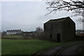
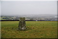
3
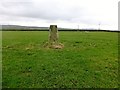
Stanhill Trig Point
Used footpath to see trig. Field in private sheep field. Asked permission from man beside 4 wheel drive vehicle. Granted so over one gate and through a second gate while man watched on. He then opened the gate for me on the way down. Footpath well signed by notices posted by Higher Stanhill Farm.
Image: © Rude Health
Taken: 26 Feb 2014
0.18 miles
4
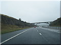
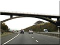
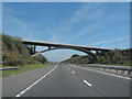
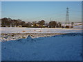
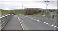
M65
Looking north from Stanhill Road
Image: © Alexander P Kapp
Taken: 8 Jan 2010
0.18 miles
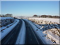
5
Trig point near Higher Stanhill
It is a wet and misty day, but you can still see the M65 motorway between Accrington and Blackburn. The nearer rooftops are in West End, Oswaldtwistle.
Image: © Bill Boaden
Taken: 15 Jan 2011
0.19 miles