IMAGES TAKEN NEAR TO
Goodshawfold Road, ROSSENDALE, BB4 8QN
Introduction
This page details the photographs taken nearby to Goodshawfold Road, BB4 8QN by members of the Geograph project.
The Geograph project started in 2005 with the aim of publishing, organising and preserving representative images for every square kilometre of Great Britain, Ireland and the Isle of Man.

There are currently over 7.5m images from over14,400 individuals and you can help contribute to the project by visiting https://www.geograph.org.uk
Image Map
Images are licensed for reuse under creativecommons.org/licenses/by-sa/2.0
Notes
- Clicking on the map will re-center to the selected point.
- The higher the marker number, the further away the image location is from the centre of the postcode.
Image Listing (19 Images Found)
Images are licensed for reuse under creativecommons.org/licenses/by-sa/2.0
Image
Details
Distance
4
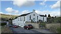
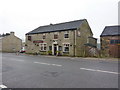
Former Chapel
At Goodshaw Fold the Rehoboth Chapel of 1852 now converted to residential
Image: © Kevin Waterhouse
Taken: 3 Mar 2024
0.06 miles
5
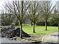
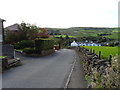
Public footpath across a garden
The path was probably once across a farmyard at Turf Pit Barn Farm but is straight ahead through the trees and across the lawn.
Image: © Kevin Waterhouse
Taken: 3 Mar 2024
0.09 miles
6
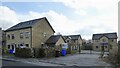
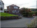
New gated housing
A small development off Goodshaw Fold Road
Image: © Kevin Waterhouse
Taken: 3 Mar 2024
0.11 miles
7
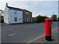
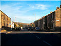
Houses on Burnley Road, Goodshaw
Showing position of Postbox No. BB4 532.
See Image] for postbox.
Image: © JThomas
Taken: 25 Sep 2018
0.12 miles
8
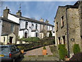
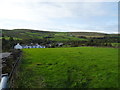
Cottages in Goodshaw Fold
The building on the right is the original Goodshawfold farmhouse.
Image
Image: © Paul Anderson
Taken: 2 Apr 2007
0.12 miles