IMAGES TAKEN NEAR TO
Barons Fold, DARWEN, BB3 3PW
Introduction
This page details the photographs taken nearby to Barons Fold, BB3 3PW by members of the Geograph project.
The Geograph project started in 2005 with the aim of publishing, organising and preserving representative images for every square kilometre of Great Britain, Ireland and the Isle of Man.

There are currently over 7.5m images from over14,400 individuals and you can help contribute to the project by visiting https://www.geograph.org.uk
Image Map
Images are licensed for reuse under creativecommons.org/licenses/by-sa/2.0
Notes
- Clicking on the map will re-center to the selected point.
- The higher the marker number, the further away the image location is from the centre of the postcode.
Image Listing (8 Images Found)
Images are licensed for reuse under creativecommons.org/licenses/by-sa/2.0
Image
Details
Distance
1
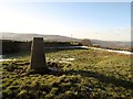
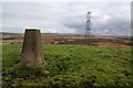
Ruston's Height
Ruston's Height, 324 metres and a P36 hill with a trig point plus a view of Darwen Tower.
Image: © Rude Health
Taken: 6 Feb 2012
0.08 miles
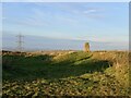
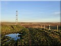
3
Trig point on Rushton's Height
In the distance is the line of the Bowland hills with Blackburn filling the lower ground.
Image: © Bill Boaden
Taken: 13 Oct 2012
0.08 miles
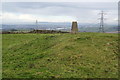
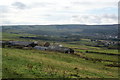
4
Trig point on Rushton's Height
This is looking east over Grey Stone Hill to the higher moors of Holcombe Moor. Rushton's Height is the highest point of a long ridge which runs from Entwistle to Hoddlesden.
Image: © Bill Boaden
Taken: 13 Oct 2012
0.08 miles
6
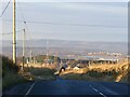
Roman Road, Rushton's Height
View down the predictably straight road towards Blackburn.
Image: © Richard Webb
Taken: 22 Nov 2021
0.10 miles
7
Lower Barn Farm
Looking from the track which leads up to Roman Road. Beyond is the valley of the River Darwen.
Image: © Bill Boaden
Taken: 13 Oct 2012
0.19 miles