IMAGES TAKEN NEAR TO
Roy Chadwick Way, BLACKBURN, BB2 7HP
Introduction
This page details the photographs taken nearby to Roy Chadwick Way, BB2 7HP by members of the Geograph project.
The Geograph project started in 2005 with the aim of publishing, organising and preserving representative images for every square kilometre of Great Britain, Ireland and the Isle of Man.

There are currently over 7.5m images from over14,400 individuals and you can help contribute to the project by visiting https://www.geograph.org.uk
Image Map
Images are licensed for reuse under creativecommons.org/licenses/by-sa/2.0
Notes
- Clicking on the map will re-center to the selected point.
- The higher the marker number, the further away the image location is from the centre of the postcode.
Image Listing (4 Images Found)
Images are licensed for reuse under creativecommons.org/licenses/by-sa/2.0
Image
Details
Distance
1
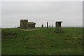
Mellor Moor
ROC bunker on Mellor Moor (223m). There is a toposcope, interpretation board explaining the observation role of the bits of concrete and a trig pillar up here. Much of the land is used for livery.
Image: © Richard Webb
Taken: 26 Mar 2004
0.14 miles
3
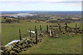
Footpath descending off Mellor Moor
Descending into the lower reaches of the Ribble Valley.
The path affords views towards Preston, and nearer at hand the disused Samlesbury Airfield and industrial complexes belonging to BAE Systems.
Image: © Chris Heaton
Taken: 20 Mar 2018
0.22 miles
4
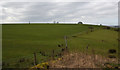
Looking SW from the top of Abbot Brow
That's the spire of St Mary's church in Mellor just peeping into view
Image: © Ian Greig
Taken: 7 Mar 2014
0.23 miles