IMAGES TAKEN NEAR TO
Mellor Lane, BLACKBURN, BB2 7EN
Introduction
This page details the photographs taken nearby to Mellor Lane, BB2 7EN by members of the Geograph project.
The Geograph project started in 2005 with the aim of publishing, organising and preserving representative images for every square kilometre of Great Britain, Ireland and the Isle of Man.

There are currently over 7.5m images from over14,400 individuals and you can help contribute to the project by visiting https://www.geograph.org.uk
Image Map
Images are licensed for reuse under creativecommons.org/licenses/by-sa/2.0
Notes
- Clicking on the map will re-center to the selected point.
- The higher the marker number, the further away the image location is from the centre of the postcode.
Image Listing (41 Images Found)
Images are licensed for reuse under creativecommons.org/licenses/by-sa/2.0
Image
Details
Distance
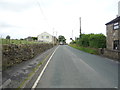
3
Old Dad's House
The mast on the horizon is on Revidge road Image
Image: © Mr T
Taken: 29 Aug 2007
0.06 miles
4
Old Dad's House, Mellor
This is trading as a small plant nursery.
Image: © Bill Boaden
Taken: 21 Jan 2011
0.07 miles
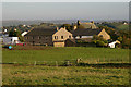
5
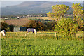
Horses grazing on Mellor Moor
Pendle Hill looms on the horizon.
Image: © Mr T
Taken: 29 Aug 2007
0.11 miles
7
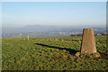
Trig Point on Mellor Moor
In the distance is Pendle Hill, and the villages of Wilpshire and Salesbury down below.
Image: © Bill Boaden
Taken: 21 Jan 2011
0.15 miles
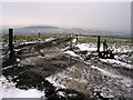
8
The top of Mellor Moor
Over to the left is the site of the nuclear monitoring post. In the distance is the Forest of Bowland, on the other side of the Ribble valley.
Image: © Bill Boaden
Taken: 21 Jan 2011
0.16 miles
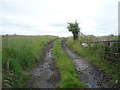
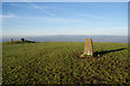
10
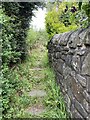
Start of footpath to Mellor trigpoint
Image: © thejackrustles
Taken: 8 Jul 2022
0.16 miles