IMAGES TAKEN NEAR TO
Under Billinge Lane, BLACKBURN, BB2 6RN
Introduction
This page details the photographs taken nearby to Under Billinge Lane, BB2 6RN by members of the Geograph project.
The Geograph project started in 2005 with the aim of publishing, organising and preserving representative images for every square kilometre of Great Britain, Ireland and the Isle of Man.

There are currently over 7.5m images from over14,400 individuals and you can help contribute to the project by visiting https://www.geograph.org.uk
Image Map
Images are licensed for reuse under creativecommons.org/licenses/by-sa/2.0
Notes
- Clicking on the map will re-center to the selected point.
- The higher the marker number, the further away the image location is from the centre of the postcode.
Image Listing (16 Images Found)
Images are licensed for reuse under creativecommons.org/licenses/by-sa/2.0
Image
Details
Distance
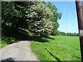
1
Looking up the track towards Billinge
Balshaw Fold Cottage (on the left) and Haydock Fold (to the right) on the track between Billinge (background) and Pleasington Cemetery.
Image: © Greum
Taken: 17 Apr 2015
0.06 miles
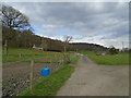
2
Lane below Vetch Hole Wood
A turn in the lane below Vetch Hole Wood on the Yellow Hills in Pleasington. The lane provides access to Lower Fold Farm, Haydock Fold and Balshaw Fold Cottage.
Image: © Greum
Taken: 27 May 2023
0.06 miles
3
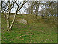
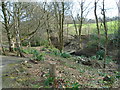
Exposed rock in Yellow Hill Wood
This formation of exposed rock, probably the product of quarrying, faces south in Yellow Hill Wood. The area of the rockface, incorporating Vetch Hole Wood to the south, features many large stony outcrops, real "ankle-breaking" terrain.
Image: © Greum
Taken: 17 Apr 2015
0.12 miles
4
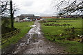
Lower Fold Farm
A farm west of Witton Park. The track just provides access to fields.
Image: © Bill Boaden
Taken: 17 Mar 2012
0.13 miles
5
View to the bridge in Crow Wood
Crow Wood in Witton is great walking & cycling country. This view to the bridge marks the transition to the steep-sided valleys of the streams coming together further downhill.
Image: © Greum
Taken: 17 Apr 2015
0.21 miles
6
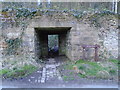
Portal to Billinge Wood
This archway on Under Billinge Lane, which also forms part of the Witton Weavers Way, affords entry to Billinge Woods.
Image: © Greum
Taken: 17 Apr 2015
0.22 miles
7
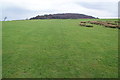
Path towards Billinge Wood
From this side, Billinge Hill doesn't seem very big. There are lovely grassy open spaces with views to south and west.
Image: © Bill Boaden
Taken: 17 Mar 2012
0.23 miles
8
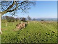
Yellow Hill
These fields, high above Blackburn, are known locally as the "Yellow Hill" because of a covering of gorse on their southern slope.
Image: © David Dixon
Taken: 5 Apr 2015
0.23 miles
9
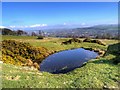
Black Hill Delf
View over the flooded delf, towards the town of Blackburn.
Image: © David Dixon
Taken: 5 Apr 2015
0.24 miles
10
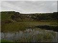
Black Hills Delf
Facing the old quarry workings with the tarn in the foreground.
Image: © Greum
Taken: 18 Sep 2016
0.24 miles