IMAGES TAKEN NEAR TO
Long Lane, BLACKBURN, BB2 6RD
Introduction
This page details the photographs taken nearby to Long Lane, BB2 6RD by members of the Geograph project.
The Geograph project started in 2005 with the aim of publishing, organising and preserving representative images for every square kilometre of Great Britain, Ireland and the Isle of Man.

There are currently over 7.5m images from over14,400 individuals and you can help contribute to the project by visiting https://www.geograph.org.uk
Image Map
Images are licensed for reuse under creativecommons.org/licenses/by-sa/2.0
Notes
- Clicking on the map will re-center to the selected point.
- The higher the marker number, the further away the image location is from the centre of the postcode.
Image Listing (28 Images Found)
Images are licensed for reuse under creativecommons.org/licenses/by-sa/2.0
Image
Details
Distance
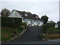
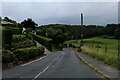
2
Cabin Hill
Long Lane becomes Woodcock Hill Road around the bend on Cabin Hill. There was a telephone box on the corner for many years after most had disappeared.
Image: © Greum
Taken: 20 May 2023
0.02 miles
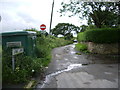
3
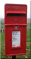
Close up, Elizabeth II postbox on Long Lane, Pleasington
Postbox No. BB2 154.
See Image] for wider view.
Image: © JThomas
Taken: 25 Oct 2018
0.02 miles
4
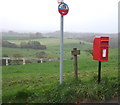
Elizabeth II postbox on Long Lane, Pleasington
Postbox No. BB2 154.
See Image] for close up.
Image: © JThomas
Taken: 25 Oct 2018
0.02 miles
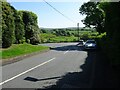
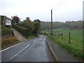
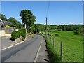
5
Long Lane
Descending towards the community of Pleasington
Image: © Chris Heaton
Taken: 11 Sep 2021
0.02 miles
6
Long Lane towards Pleasington
Looking east.
Image: © JThomas
Taken: 25 Oct 2018
0.03 miles
9
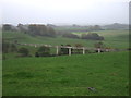
Grazing towards waste water conduit
Conduit carries the waste water of Blackburn to the sewage works.
Image: © JThomas
Taken: 25 Oct 2018
0.09 miles
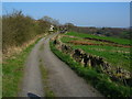
10
Long Lane
Long Lane is the name of this stretch of the road between Feniscowles and Billinge above Pleasington. This image pictures the descent towards Trout Brook.
Image: © Greum
Taken: 20 May 2023
0.10 miles