IMAGES TAKEN NEAR TO
St. Silas's Road, BLACKBURN, BB2 6JX
Introduction
This page details the photographs taken nearby to St. Silas's Road, BB2 6JX by members of the Geograph project.
The Geograph project started in 2005 with the aim of publishing, organising and preserving representative images for every square kilometre of Great Britain, Ireland and the Isle of Man.

There are currently over 7.5m images from over14,400 individuals and you can help contribute to the project by visiting https://www.geograph.org.uk
Image Map
Images are licensed for reuse under creativecommons.org/licenses/by-sa/2.0
Notes
- Clicking on the map will re-center to the selected point.
- The higher the marker number, the further away the image location is from the centre of the postcode.
Image Listing (43 Images Found)
Images are licensed for reuse under creativecommons.org/licenses/by-sa/2.0
Image
Details
Distance
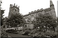
1

The Parish Church of St Silas, Blackburn
Image: © Alexander P Kapp
Taken: 27 Apr 2007
0.04 miles
2
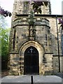
Porch, The Parish Church of St Silas, Blackburn
Image: © Alexander P Kapp
Taken: 27 Apr 2007
0.04 miles
3
The Parish Church of St Silas, Blackburn
Image: © Alexander P Kapp
Taken: 27 Apr 2007
0.05 miles
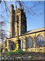
4
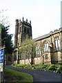
St Silas' Church, Blackburn
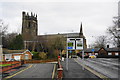
St Silas' Parish Church, is located on Preston New Road. Constructed in sandstone with freestone dressings, the church was completed in 1898 although it had been designed twenty years earlier, in 1878, by the Lancaster architects Paley and Austin. The tower, which is 104 feet in height, was not added until 1913–14 http://en.wikipedia.org/wiki/St_Silas'_Church,_Blackburn .
The church has been designated by English Heritage as a Grade II* listed building (English Heritage Building ID: 416923 http://www.britishlistedbuildings.co.uk/en-416923-church-of-st-silas- British Listed Buildings).
Image: © David Dixon
Taken: 5 Apr 2015
0.05 miles
5
St Silas' Parish Centre
Former sunday school building dated 1834.
Image: © David Dixon
Taken: 5 Apr 2015
0.05 miles
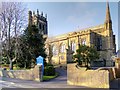
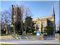
6
St. Silas, Preston New Rd., Blackburn
Image: © Andrew Mathewson
Taken: 23 Aug 2009
0.05 miles
7
Blackburn, St Silas' Church
St Silas' Parish Church, is located on Preston New Road. Constructed in sandstone with freestone dressings, the church was completed in 1898 although it had been designed twenty years earlier, in 1878, by the Lancaster architects Paley and Austin. The tower, which is 104 feet in height, was not added until 1913–14 http://en.wikipedia.org/wiki/St_Silas'_Church,_Blackburn .
The church has been designated by English Heritage as a Grade II* listed building (English Heritage Building ID: 416923 http://www.britishlistedbuildings.co.uk/en-416923-church-of-st-silas- British Listed Buildings).
Image: © David Dixon
Taken: 5 Apr 2015
0.05 miles
8
St Silas' Church and War Memorial
St Silas' Parish Church, is located on Preston New Road. Constructed in sandstone with freestone dressings, the church was completed in 1898 although it had been designed twenty years earlier, in 1878, by the Lancaster architects Paley and Austin. The tower, which is 104 feet in height, was not added until 1913–14 http://en.wikipedia.org/wiki/St_Silas'_Church,_Blackburn .
The church has been designated by English Heritage as a Grade II* listed building (English Heritage Building ID: 416923 http://www.britishlistedbuildings.co.uk/en-416923-church-of-st-silas- British Listed Buildings).
Image: © David Dixon
Taken: 5 Apr 2015
0.06 miles
9
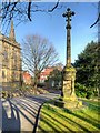
The War Memorial outside St Silas' Church
The war memorial standing in front of St Silas' Church in Blackburn reads:
TO THE GLORY OF GOD
IN HONOURED MEMORY
OF THE MEN
OF THIS CHURCH
WHO GAVE THEIR LIVES
FOR THE EMPIRE
IN THE GREAT WAR
1914 - 1919
see Image]
Image: © David Dixon
Taken: 5 Apr 2015
0.06 miles
10
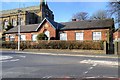
The top of Billinge Avenue and St Silas
At the top is the main road from Blackburn towards Preston. The church of St Silas is a major landmark.
Image: © Bill Boaden
Taken: 17 Mar 2012
0.06 miles