IMAGES TAKEN NEAR TO
Stockclough Lane, BLACKBURN, BB2 5JR
Introduction
This page details the photographs taken nearby to Stockclough Lane, BB2 5JR by members of the Geograph project.
The Geograph project started in 2005 with the aim of publishing, organising and preserving representative images for every square kilometre of Great Britain, Ireland and the Isle of Man.

There are currently over 7.5m images from over14,400 individuals and you can help contribute to the project by visiting https://www.geograph.org.uk
Image Map
Images are licensed for reuse under creativecommons.org/licenses/by-sa/2.0
Notes
- Clicking on the map will re-center to the selected point.
- The higher the marker number, the further away the image location is from the centre of the postcode.
Image Listing (14 Images Found)
Images are licensed for reuse under creativecommons.org/licenses/by-sa/2.0
Image
Details
Distance
1
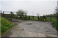
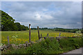
Entrance to Stock Clough Quarry
The former quarry was used for landfill but has now been closed. It will possibly be developed as a leisure facility.
Image: © Bill Boaden
Taken: 23 Apr 2011
0.05 miles

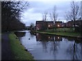
4
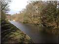
Leeds-Liverpool Canal south of Feniscowles
Image: © John H Darch
Taken: 10 Mar 2013
0.08 miles
5
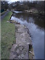
Bit of a bulge
This small section of the canal is narrowed by this bulge whose purpose is unclear. The second coping stone from the viewer, just beyond the stepped section, contains a surveyor's benchmark.
Image: © Ian Paterson
Taken: 21 Feb 2012
0.08 miles
7
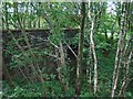
Bridge near Lower Stockclough
A bridge on the disused Cherry Tree-Chorley railway, now crossed by a footpath leading south-west from Lower Stockclough.
Image: © Greum
Taken: 3 Jul 2015
0.14 miles
8
Navigation lights
These canada geese can swim all night, navigating by the light from the rear of the houses on the bank!
Image: © Ian Paterson
Taken: 21 Feb 2012
0.18 miles
9
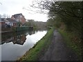
Canal towpath at Feniscowles
The towpath on the Leeds & Liverpool Canal heading out of Feniscowles towards Stanworth (eventually).
Image: © Greum
Taken: 30 Mar 2023
0.18 miles
10
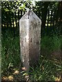
Old milemarker by the Leeds & Liverpool Canal, Feniscowles
Milemarker by the Leeds & Liverpool Canal, in parish of Livesey (Blackburn with Darwen District), approx 180 metres South of bridge 93B, Feniscowle's Bridge, Northeast of power station.
Mileage plates lost.
Surveyed
Milestone Society National ID: LLC-053
Image: © Milestone Society
Taken: Unknown
0.18 miles