IMAGES TAKEN NEAR TO
Cravens Hollow, BLACKBURN, BB2 4LH
Introduction
This page details the photographs taken nearby to Cravens Hollow, BB2 4LH by members of the Geograph project.
The Geograph project started in 2005 with the aim of publishing, organising and preserving representative images for every square kilometre of Great Britain, Ireland and the Isle of Man.

There are currently over 7.5m images from over14,400 individuals and you can help contribute to the project by visiting https://www.geograph.org.uk
Image Map
Images are licensed for reuse under creativecommons.org/licenses/by-sa/2.0
Notes
- Clicking on the map will re-center to the selected point.
- The higher the marker number, the further away the image location is from the centre of the postcode.
Image Listing (16 Images Found)
Images are licensed for reuse under creativecommons.org/licenses/by-sa/2.0
Image
Details
Distance
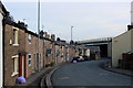
2
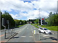
Jack Walker Way at Earcroft from Bolton Road
Image: © Raymond Knapman
Taken: 30 Jul 2015
0.09 miles
4
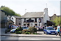
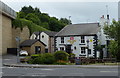
The Golden Cup on matchday
Blackburn Rovers fans regularly gather here before walking down the Bolton Road.
Image: © Bill Boaden
Taken: 9 Apr 2011
0.16 miles
5
Golden Cup in Darwen
Thwaites public house on Blackburn Road.
Image: © Mat Fascione
Taken: 17 Jul 2016
0.16 miles
6
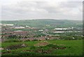
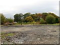
Earcroft
The nearer houses of Earcroft are in the square which is also occupied by grazing land for sheep and cattle above Blackburn. The motorway is the M65, the new motorway has spawned a lot of tin sheeting big buildings, often distribution centres. In the foreground a hole has recently been dug, being a hill top above a motorway, I suspect a foundation for a phone mast?
Image: © Richard Webb
Taken: 14 May 2004
0.17 miles
7
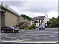
The Golden Cup
A pub on the Bolton Road next to the M65 motorway bridge in Darwen.
Image: © Gordon Griffiths
Taken: 20 Jun 2009
0.18 miles
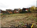
9
Bog Height Road, Earcroft
Leading down to the A666, just below the M65 positioned high above the scene on a flyover
Image: © Chris Heaton
Taken: 8 Jan 2020
0.18 miles
10
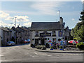
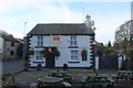
Golden Cup
Bog Height Road and the Golden Cup public house, at Earcroft.
Image: © David Dixon
Taken: 23 Jul 2011
0.19 miles