IMAGES TAKEN NEAR TO
Ansdell Terrace, BLACKBURN, BB2 3JL
Introduction
This page details the photographs taken nearby to Ansdell Terrace, BB2 3JL by members of the Geograph project.
The Geograph project started in 2005 with the aim of publishing, organising and preserving representative images for every square kilometre of Great Britain, Ireland and the Isle of Man.

There are currently over 7.5m images from over14,400 individuals and you can help contribute to the project by visiting https://www.geograph.org.uk
Image Map
Images are licensed for reuse under creativecommons.org/licenses/by-sa/2.0
Notes
- Clicking on the map will re-center to the selected point.
- The higher the marker number, the further away the image location is from the centre of the postcode.
Image Listing (7 Images Found)
Images are licensed for reuse under creativecommons.org/licenses/by-sa/2.0
Image
Details
Distance
5
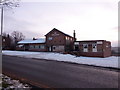
The Manxman, Manxman Road, Blackburn
Image: © Alexander P Kapp
Taken: 14 Jan 2010
0.18 miles
6
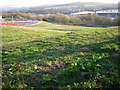
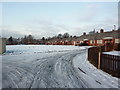
View from Sunny Bank Road, Blackburn
A new playground has been built on the open land between Sunny Bank Road and the railway from Blackburn to Darwen. Ewood Park Stadium is to the right.
Image: © Kenneth Yarham
Taken: 5 Apr 2007
0.24 miles
7
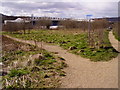
Footpaths across open land near Ewood Park
The scrubby area between the River Darwen and the railway from Blackburn to Darwen, with Blackburn Rovers' Ewood Park Stadium beyond the river.
Image: © Kenneth Yarham
Taken: 5 Apr 2007
0.25 miles