IMAGES TAKEN NEAR TO
Cranshaw Drive, BLACKBURN, BB1 8RE
Introduction
This page details the photographs taken nearby to Cranshaw Drive, BB1 8RE by members of the Geograph project.
The Geograph project started in 2005 with the aim of publishing, organising and preserving representative images for every square kilometre of Great Britain, Ireland and the Isle of Man.

There are currently over 7.5m images from over14,400 individuals and you can help contribute to the project by visiting https://www.geograph.org.uk
Image Map
Images are licensed for reuse under creativecommons.org/licenses/by-sa/2.0
Notes
- Clicking on the map will re-center to the selected point.
- The higher the marker number, the further away the image location is from the centre of the postcode.
Image Listing (18 Images Found)
Images are licensed for reuse under creativecommons.org/licenses/by-sa/2.0
Image
Details
Distance
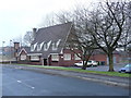
3
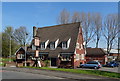
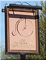
The Farthings public house
On Rosewood Avenue
Image: © JThomas
Taken: 19 Apr 2019
0.09 miles
5
The Farthings .
Public house on Rosewood Avenue.
Image: © Tony Mercer
Taken: 1 Jan 2009
0.09 miles
6
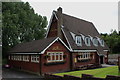
The Farthings on Rosewood Avenue
Modern public house whose outstanding feature is the unusual steepness to the roof - located in the northern suburbs of Blackburn.
Image: © Chris Heaton
Taken: 20 Jul 2017
0.09 miles
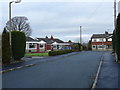
7
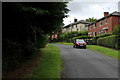
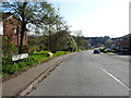
Briar Road, Blackburn
Crescent off Rosewood Avenue
Image: © Chris Heaton
Taken: 20 Jul 2017
0.10 miles
8
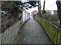
Ginnel, Openshaw Drive
Alleyway between Openshaw Drive and Royshaw Close.
Image: © Tony Mercer
Taken: 8 Jan 2009
0.13 miles
9
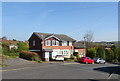
Royshaw Close
Cul-de-sac on Royshaw estate.
Image: © Tony Mercer
Taken: 8 Jan 2009
0.17 miles
10
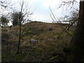
Royshaw Hill
Land bounded by Royshaw Close/Avenue, Pleck Farm Avenue and Pleckgate Road.
Image: © Tony Mercer
Taken: 8 Jan 2009
0.18 miles