IMAGES TAKEN NEAR TO
Wilworth Crescent, BLACKBURN, BB1 8QN
Introduction
This page details the photographs taken nearby to Wilworth Crescent, BB1 8QN by members of the Geograph project.
The Geograph project started in 2005 with the aim of publishing, organising and preserving representative images for every square kilometre of Great Britain, Ireland and the Isle of Man.

There are currently over 7.5m images from over14,400 individuals and you can help contribute to the project by visiting https://www.geograph.org.uk
Image Map
Images are licensed for reuse under creativecommons.org/licenses/by-sa/2.0
Notes
- Clicking on the map will re-center to the selected point.
- The higher the marker number, the further away the image location is from the centre of the postcode.
Image Listing (13 Images Found)
Images are licensed for reuse under creativecommons.org/licenses/by-sa/2.0
Image
Details
Distance
1
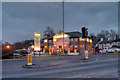
The Knowles Arms
A large bar and (Mediterranean style) restaurant at the junction of Pleckgate Road with Ramsgreave Drive.
Image: © David Dixon
Taken: 11 Mar 2018
0.10 miles
2
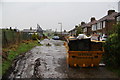
Ramsgreave Avenue
An unmade road with bollards to prevent this being used as a cut through.
Image: © Bill Boaden
Taken: 31 Dec 2011
0.12 miles
3
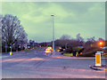
A6119, Ramsgreave Drive
The A6119 forms a northern half-ring road around Blackburn. It is still remains a busy local route although much of its strategic importance has been lost since the opening of the M65 in 1997.
Image: © David Dixon
Taken: 11 Mar 2018
0.13 miles
5
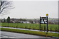
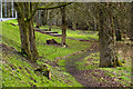
Neighbourhood noticeboard by Woolridge Playing Fields
Community playing fields opposite Pleckgate High School. It's drizzling incessantly.
Image: © Bill Boaden
Taken: 31 Dec 2011
0.18 miles
6
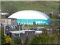
Sports Hall.
Inflatable sports hall at Lammack school. Viewed from Royshaw Hill.
Image: © Tony Mercer
Taken: 4 Mar 2008
0.19 miles
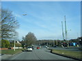
7
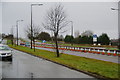
Ramsgreave Drive
This is Blackburn's northern ring road. The cones seem to have been here for quite a while. The nearest lane is for residents' access and parking. On the far side is Blackburn RUFC.
Image: © Bill Boaden
Taken: 31 Dec 2011
0.19 miles
8
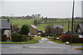
Kay Fold Farm
Just off Blackburn's northern ring road.
Image: © Bill Boaden
Taken: 31 Dec 2011
0.20 miles
10
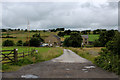
Access to Kay Fold Farm
Leading from the A6119 - northern by pass around Blackburn
Image: © Chris Heaton
Taken: 20 Jul 2017
0.21 miles