IMAGES TAKEN NEAR TO
Moorgate Road, BARNOLDSWICK, BB18 5SQ
Introduction
This page details the photographs taken nearby to Moorgate Road, BB18 5SQ by members of the Geograph project.
The Geograph project started in 2005 with the aim of publishing, organising and preserving representative images for every square kilometre of Great Britain, Ireland and the Isle of Man.

There are currently over 7.5m images from over14,400 individuals and you can help contribute to the project by visiting https://www.geograph.org.uk
Image Map
Images are licensed for reuse under creativecommons.org/licenses/by-sa/2.0
Notes
- Clicking on the map will re-center to the selected point.
- The higher the marker number, the further away the image location is from the centre of the postcode.
Image Listing (13 Images Found)
Images are licensed for reuse under creativecommons.org/licenses/by-sa/2.0
Image
Details
Distance
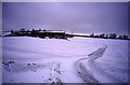
1
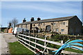
Duck Pond (Farm)
Formerly this was in use as for boarding kennels and a cattery.
Image: © Dr Neil Clifton
Taken: 10 Apr 2011
0.00 miles
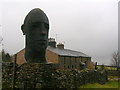
2
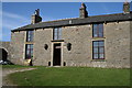
Duck Pond (Farm)
Note the small sculpted heads mounted either side of the front door
Image: © Dr Neil Clifton
Taken: 10 Apr 2011
0.01 miles
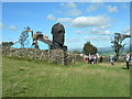
3
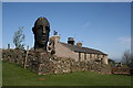
Duck Pond Farm with sculpted heads
This shows the position of the large sculpted heads in relationship to the farm.
Image: © Dr Neil Clifton
Taken: 10 Apr 2011
0.01 miles
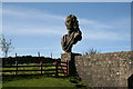
4
Male sculpted head at Duck Pond
See also Image
Image: © Dr Neil Clifton
Taken: 10 Apr 2011
0.02 miles
5
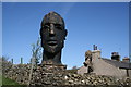
Head sculpture at Duck Pond
One of two large sculpted heads mounted outside the farm. These heads are fine pieces of work, but inevitably at this height in the Pennines, they are becoming the victims of erosion.
Image: © Dr Neil Clifton
Taken: 10 Apr 2011
0.03 miles
6
Sculpture at Duck Pond
This isolated moorland farm sports two large sculptures.
Image: © John H Darch
Taken: 11 Feb 2011
0.03 miles
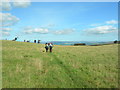
7
Duck Pond
With fellow walkers on a guided walk from the Pendle Walking Festival 2009 (White Moor and Weets) led by Mr Roger Haythornthwaite. Nice walk on a grand day.
Image: © John Topping
Taken: 10 Sep 2009
0.03 miles
8
Approaching Duck Pond
On the path from Star Hall.
Image: © John Topping
Taken: 10 Sep 2009
0.06 miles
9
Duck Pond
A farm called Duck Pond on the appropriately named White Moor. Remote, windswept and very cold
Image: © Chris Heaton
Taken: 16 Feb 2000
0.07 miles
10
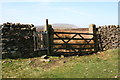
Gate onto the open moor
This shows the gate leading to the open moor above Duck Pond Farm, with public footpath to access Gisburn Old Road. There are no bridleway rights here, they only extend as far as the farm.
Image: © Dr Neil Clifton
Taken: 10 Apr 2011
0.10 miles