IMAGES TAKEN NEAR TO
Skipton Road, BARNOLDSWICK, BB18 5NB
Introduction
This page details the photographs taken nearby to Skipton Road, BB18 5NB by members of the Geograph project.
The Geograph project started in 2005 with the aim of publishing, organising and preserving representative images for every square kilometre of Great Britain, Ireland and the Isle of Man.

There are currently over 7.5m images from over14,400 individuals and you can help contribute to the project by visiting https://www.geograph.org.uk
Image Map
Images are licensed for reuse under creativecommons.org/licenses/by-sa/2.0
Notes
- Clicking on the map will re-center to the selected point.
- The higher the marker number, the further away the image location is from the centre of the postcode.
Image Listing (480 Images Found)
Images are licensed for reuse under creativecommons.org/licenses/by-sa/2.0
Image
Details
Distance
1
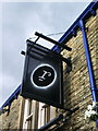
The ultra modern
The new sign for the "Railway" pub
Image: © Alexander P Kapp
Taken: 27 Aug 2007
0.01 miles
2
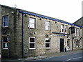
The Railway
Its has some very modern signs for a pub of its ilk
Image: © Alexander P Kapp
Taken: 27 Aug 2007
0.01 miles
3
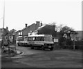
Station Road, Barnoldswick (3)
In the late 80s, a Barnoldswick Local bus service, operated by Burnley and Pendle Transport using Mercedes midi-buses, was inaugurated. Two circular routes are operated, numbered 30 and 31, and the service has been popular enough to survive into 2008. Initially it was branded 'Whizzard', a somewhat contrived connection with the witchcraft associations of the area.
Image: © Dr Neil Clifton
Taken: 29 Dec 1988
0.02 miles
4
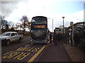
Barnoldswick: A Bank Holiday Treat
On Sundays and Bank Holiday Mondays, Route 872 from Nelson to Grassington runs, and is seen here at Fernlea Avenue, Barnoldswick. Comfortable doubledeckers are used on this route (the vehicles are used on the prestige 'Witch Way' service during the week), and the service is deservedly popular. This particular bus was the 09:59 departure from Barnoldswick, running about ten minutes late. It left Barnoldswick with all seats`taken and some standing passengers.
Image: © Dr Neil Clifton
Taken: 4 May 2015
0.02 miles
5
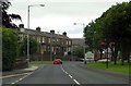
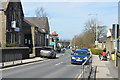
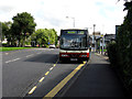
Barnoldswick: Skipton Road
This is the inner end of Skipton Road, detached by road alterations from the main part of the road. Looking here towards the middle of Barnoldswick.
Image: © Dr Neil Clifton
Taken: 20 Aug 2012
0.02 miles
7

Holy Trinity Parish Church - viewed from Wellhouse Road
Image: © Betty Longbottom
Taken: 30 Jul 2016
0.02 miles
8
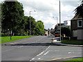
Barnoldswick: Fernlea Avenue
To the right is the 'fag-end' of Skipton Road, leading to the centre of Barnoldswick. In the middle distance, an orange Dennis single-decker bus belonging to Pennine Motor Services awaits its departure time for Skipton.
Image: © Dr Neil Clifton
Taken: 20 Aug 2012
0.03 miles
9
Barnoldswick: Fernlea Avenue
With Transdev Burnley & Pendle bus. This vehicle is on its layover: it will not depart from here, but will run round onto Station Road to form the 15:28 departure for Burnley. The route number indicator is, however, wrongly set and should be reading 29.
Image: © Dr Neil Clifton
Taken: 20 Aug 2012
0.03 miles