IMAGES TAKEN NEAR TO
Milton Grove, BARNOLDSWICK, BB18 5JG
Introduction
This page details the photographs taken nearby to Milton Grove, BB18 5JG by members of the Geograph project.
The Geograph project started in 2005 with the aim of publishing, organising and preserving representative images for every square kilometre of Great Britain, Ireland and the Isle of Man.

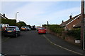
There are currently over 7.5m images from over14,400 individuals and you can help contribute to the project by visiting https://www.geograph.org.uk
Image Map (Loading...)


Getting Data...Please wait
Leaflet Map data © OpenStreetMap
Images are licensed for reuse under creativecommons.org/licenses/by-sa/2.0
Notes
- Clicking on the map will re-center to the selected point.
- The higher the marker number, the further away the image location is from the centre of the postcode.
Image Listing (168 Images Found)
Images are licensed for reuse under creativecommons.org/licenses/by-sa/2.0
Image
Details
Distance
1
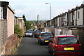
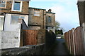
Backs of Coniston Avenue and Rosemount Avenue, Barnoldswick
Conisto Avenue is a normal road, with semi-detached houses of which the backs are seen on the left of this photograph. But Rosemount Avenue does not have a normal 'front', as the road here was divided up into gardens some years ago, (I suspect in the 1970s but would stand coorection on this), so the only access these terrace houses have for cars is via this back lane.
Image: © Dr Neil Clifton
Taken: 8 Jul 2007
0.02 miles
2
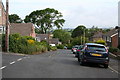
Coniston Avenue, Barnoldswick, Yorkshire
Coniston Avenue joins the top end of Frederick Street to Fern Bank Avenue. This photograph is looking north west towards the Fern Bank Avenue end. There are only eight houses numbered in Coniston Avenue, 1 to 15 odd numbers from the far end. Some of these houses are visible on the right. The houses on the left are numbered in Ambleside Avenue, a cul-de-sac.
Image: © Dr Neil Clifton
Taken: 8 Jul 2007
0.02 miles
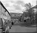
3
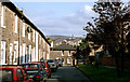
Barnoldswick: Frederick Street
Looking south-east towards Richmand Road.
Image: © Dr Neil Clifton
Taken: 26 Aug 1991
0.02 miles
4
Byron Grove, Barnoldswick, Yorkshire
Byron Grove is just a short street, running up from Frederick Street to Dickens Avenue. Only four houses have numbers on Byron Grove: from the near end (Frederick Street), Nos 1,3,5 and 7. It is surprising that the numbers given were not 2,4,6 and 8, as, in Barnoldswick and in most other Northern towns, the convention is to allocate odd numbers to the left and even to the right, when starting from the lower-numbered end.
Image: © Dr Neil Clifton
Taken: 8 Jul 2007
0.02 miles
5
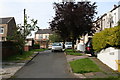
Ambleside Avenue, Barnoldswick, Yorkshire
Ambleside Avenue is a cul-de-sac off the west side of Coniston Avenue. Most of its houses are post-WWII bungalows in the private sector.
Image: © Dr Neil Clifton
Taken: 8 Jul 2007
0.02 miles
6
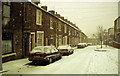
Not the best of weather
Sometimes it snows,even in sunny Barnoldswick. This is Frederick Street in January 1994.
Image: © Dr Neil Clifton
Taken: Unknown
0.03 miles
8
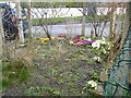
Barnoldswick: 34 Frederick Street
Even small gardens can be attractive with spring flowers.
Image: © Dr Neil Clifton
Taken: 13 Mar 2017
0.04 miles
9
Barnoldswick: 34 Frederick Street
Rear view of this end-of-terrace house
Image: © Dr Neil Clifton
Taken: 10 Apr 2017
0.04 miles
10
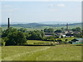
Barnoldswick Mill Chimneys
On the left is Fernbank Mill (formerly occupied by Lontex and now used by a number of smaller companies) and on the right is Westfield Mill (formerly occupied by Dermide and now designated to be demolished for housing). Photograph taken from near Cow Pasture Farm.
Image: © Malcolm Sterratt
Taken: 8 Jul 2005
0.04 miles