IMAGES TAKEN NEAR TO
Richmond Avenue, BARNOLDSWICK, BB18 5JB
Introduction
This page details the photographs taken nearby to Richmond Avenue, BB18 5JB by members of the Geograph project.
The Geograph project started in 2005 with the aim of publishing, organising and preserving representative images for every square kilometre of Great Britain, Ireland and the Isle of Man.

There are currently over 7.5m images from over14,400 individuals and you can help contribute to the project by visiting https://www.geograph.org.uk
Image Map (Loading...)


Getting Data...Please wait
Leaflet Map data © OpenStreetMap
Images are licensed for reuse under creativecommons.org/licenses/by-sa/2.0
Notes
- Clicking on the map will re-center to the selected point.
- The higher the marker number, the further away the image location is from the centre of the postcode.
Image Listing (208 Images Found)
Images are licensed for reuse under creativecommons.org/licenses/by-sa/2.0
Image
Details
Distance
1
Frederick Street, Barnoldswick
From its junction with Richmond Road. The other end of Frederick Street runs into Coniston Avenue, which has newer houses.
Image: © Dr Neil Clifton
Taken: 20 Dec 2005
0.00 miles
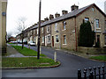
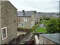
2
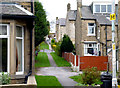
Barnoldswick: Richmond Avenue
A short cul-de-sac, seen from Richmond Road
Image: © Dr Neil Clifton
Taken: 8 Apr 2012
0.01 miles
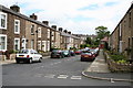
3
Frederick Street, Barnoldswick, Yorkshire (2)
Like most Pennine towns, Barnoldswick has many steep streets of terrace houses, here stone-built and still sound. It's Monday morning, so most of the motor cars often parked here are absent. A lady makes her way homeward carrying shopping.
Image: © Dr Neil Clifton
Taken: 9 Oct 2006
0.02 miles
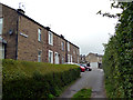
4
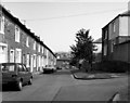
Denton Street, Barnoldswick, Yorkshire
Looking south-east from the junction with Richmond Road. At the far end, Denton Street forms a T-junction with Harper Street.
Image: © Dr Neil Clifton
Taken: 7 Jul 2007
0.02 miles
5
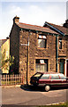
34, Frederick Street, Barnoldswick
This house was added after the main terrace was built, and dates from around 1905
Image: © Dr Neil Clifton
Taken: 8 Sep 1991
0.02 miles
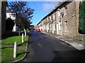
6
Frederick Street, Barnoldswick
At the far end this street forms a T-junction with Richmond Road. The road up to the right is Byron Grove.
Image: © Dr Neil Clifton
Taken: 21 Jul 1990
0.02 miles

8
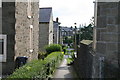
Barnoldswick: Footpath to Frederick Street
This footpath, protected by bollards from access by cars, leads up from Gisburn Road to the top end of Frederick Street and Coniston Avenue
Image: © Dr Neil Clifton
Taken: 8 Apr 2012
0.02 miles
9
Looking down the backs in Barnoldswick
This footpath runs down from Frederick Street to Gisburn Road. The house on the immediate right is 34 Frederick Street, and that on the left is 1 Rosemount Avenue. At the far end the path disgorges onto Gisburn Road.
Image: © Dr Neil Clifton
Taken: 8 Jul 2007
0.02 miles
10
View down the 'Catwalk'
This path, which connects the upper end of Frederick Street with Gisburn Road, is popularly known as the 'Catwalk' because of the frequency in which it is used by such animals. The shot was taken from the upper window in No 34, Frederick Street.
Image: © Dr Neil Clifton
Taken: 11 Jul 2017
0.03 miles