IMAGES TAKEN NEAR TO
Bracewell Street, BARNOLDSWICK, BB18 5EP
Introduction
This page details the photographs taken nearby to Bracewell Street, BB18 5EP by members of the Geograph project.
The Geograph project started in 2005 with the aim of publishing, organising and preserving representative images for every square kilometre of Great Britain, Ireland and the Isle of Man.

There are currently over 7.5m images from over14,400 individuals and you can help contribute to the project by visiting https://www.geograph.org.uk
Image Map (Loading...)


Getting Data...Please wait
Leaflet Map data © OpenStreetMap
Images are licensed for reuse under creativecommons.org/licenses/by-sa/2.0
Notes
- Clicking on the map will re-center to the selected point.
- The higher the marker number, the further away the image location is from the centre of the postcode.
Image Listing (191 Images Found)
Images are licensed for reuse under creativecommons.org/licenses/by-sa/2.0
Image
Details
Distance
1
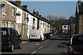
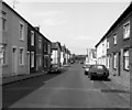
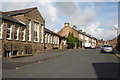
Barnoldswick: Bracewell Street
Plenty of older terrace houses still remain in the town.
Image: © Dr Neil Clifton
Taken: 8 Apr 2017
0.02 miles
2
Barnoldswick: Brogden Street
Looking northeast from its junction with Bolland Street
Image: © Dr Neil Clifton
Taken: 5 May 2011
0.02 miles
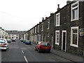
3
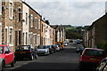
Brogden Street, Barnoldswick, Yorkshire
The short Brogden Street runs slightly downhill from a junction with Bolland Street, where the photographer is standing, to a junction with Colin Street at the lower end
Image: © Dr Neil Clifton
Taken: 8 Jul 2007
0.03 miles
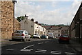
4
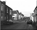
Bolland Street, Barnoldswick, looking south-east
This is taken from Edmondson Street, looking south-east along Bolland Street, to the far end where it meets Gisburn Street.
Image: © Dr Neil Clifton
Taken: 8 Jul 2007
0.03 miles
5
Gisburn Street, Barnoldswick
This street starts at a T-junction with Gisburn Road and runs down just east of northerly to a T-junction with West Close Road at the far end. Streets off on the left are Bracewell Street and Colin Street.
Image: © Dr Neil Clifton
Taken: 21 Jul 1990
0.04 miles
6
Gisburn Street, Barnoldswick, Yorkshire
Compare this with my 1990 photograph Image
Image: © Dr Neil Clifton
Taken: 8 Jul 2007
0.04 miles
7
Gisburn Street, Barnoldswick
This street runs north-eastwards off the main road, Gisburn Road. On the left of Gisburn Street can be seen its junctions with Bracewell Street and Colin Street. At the far end, Gisburn Street runs into West Close Road, but all vehicles must turn right at this point, as the portion of West Close Road to the left is unmade.
Image: © Dr Neil Clifton
Taken: 12 May 1990
0.04 miles
8
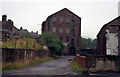
Barnoldswick's oldest mill
See Image Another photograph showing the old corn mill from the other end, before new building obscured the view.
Image: © Dr Neil Clifton
Taken: 9 Aug 1992
0.04 miles
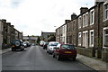
9
Bolland Street, Barnoldswick, Yorkshire
This street runs northwestwards from a junction with Gisburn Street to a similar T-junction with Edmondson Street at its far end.
Image: © Dr Neil Clifton
Taken: 8 Jul 2007
0.05 miles
10
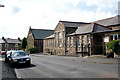
Barnoldswick: St. Joseph's Parish Centre
This building was formerly the RC junior school, until replaced by a modern building close by, and is now used as the Parish Centre.
Image: © Dr Neil Clifton
Taken: 8 Jul 2007
0.06 miles