IMAGES TAKEN NEAR TO
Derwent Close, BLACKBURN, BB1 4EJ
Introduction
This page details the photographs taken nearby to Derwent Close, BB1 4EJ by members of the Geograph project.
The Geograph project started in 2005 with the aim of publishing, organising and preserving representative images for every square kilometre of Great Britain, Ireland and the Isle of Man.

There are currently over 7.5m images from over14,400 individuals and you can help contribute to the project by visiting https://www.geograph.org.uk
Image Map
Images are licensed for reuse under creativecommons.org/licenses/by-sa/2.0
Notes
- Clicking on the map will re-center to the selected point.
- The higher the marker number, the further away the image location is from the centre of the postcode.
Image Listing (20 Images Found)
Images are licensed for reuse under creativecommons.org/licenses/by-sa/2.0
Image
Details
Distance
3
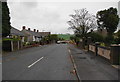
Devonshire Road, Rishton
Leading only to newer housing developments.
Image: © Bill Boaden
Taken: 17 Oct 2010
0.13 miles
4
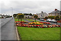
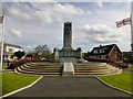
A colourful display
Public gardens between The Esplanade and Blackburn Road.
Image: © Bill Boaden
Taken: 17 Oct 2010
0.14 miles
5
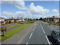
Blackburn Road at Rishton
War memorial on the right of view
Image: © Raymond Knapman
Taken: 30 Jul 2015
0.15 miles
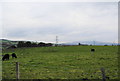
7
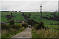
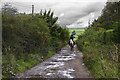
Cut Lane approaching Cut Farm
The Leeds and Liverpool Canal runs in the dip ahead, but there is no river as might be expected.
Image: © Bill Boaden
Taken: 17 Oct 2010
0.16 miles
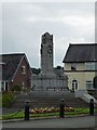
8
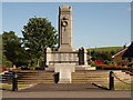
Rishton War Memorial
This is the war memorial opposite the esplanade in Rishton, on the main road from Rishton towards Blackburn.
Image: © Steve Houldsworth
Taken: 12 Jun 2010
0.16 miles