IMAGES TAKEN NEAR TO
Coal Clough Lane, BURNLEY, BB11 4PG
Introduction
This page details the photographs taken nearby to Coal Clough Lane, BB11 4PG by members of the Geograph project.
The Geograph project started in 2005 with the aim of publishing, organising and preserving representative images for every square kilometre of Great Britain, Ireland and the Isle of Man.

There are currently over 7.5m images from over14,400 individuals and you can help contribute to the project by visiting https://www.geograph.org.uk
Image Map (Loading...)


Getting Data...Please wait
Leaflet Map data © OpenStreetMap
Images are licensed for reuse under creativecommons.org/licenses/by-sa/2.0
Notes
- Clicking on the map will re-center to the selected point.
- The higher the marker number, the further away the image location is from the centre of the postcode.
Image Listing (87 Images Found)
Images are licensed for reuse under creativecommons.org/licenses/by-sa/2.0
Image
Details
Distance
1
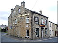
Coal Clough, Coal Clough Lane, Burnley
Image: © Alexander P Kapp
Taken: 8 Jul 2008
0.01 miles
2
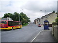
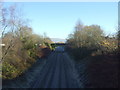
Coal Clough Lane, Burnley
Looking up Coal Clough Lane from the railway
Image: © Alexander P Kapp
Taken: 8 Jul 2008
0.02 miles
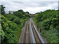
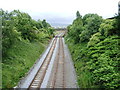
5
Railway towards Leeds
Looking east from the bridge on Coal Clough Lane.
Image: © JThomas
Taken: 26 Nov 2016
0.06 miles
6
Preston to Todmorden Railway
Looking west from Coal Clough Lane Bridge
Image: © Alexander P Kapp
Taken: 8 Jul 2008
0.07 miles
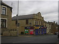
7
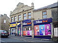
Former Burnley Co-operative Society Branch
Image: © Alexander P Kapp
Taken: 8 Jul 2008
0.07 miles
9
Preston to Todmorden Railway
Looking east from Coal Clough Lane Bridge
Image: © Alexander P Kapp
Taken: 8 Jul 2008
0.08 miles
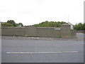
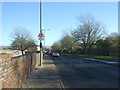
10
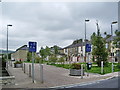
Westmorland Street
Knocked down a row of houses down and built a "Home Zone" http://www.homezones.org/concept.html
Image: © Alexander P Kapp
Taken: 8 Jul 2008
0.09 miles