IMAGES TAKEN NEAR TO
Railway Street, BURNLEY, BB11 1DA
Introduction
This page details the photographs taken nearby to Railway Street, BB11 1DA by members of the Geograph project.
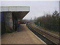
The Geograph project started in 2005 with the aim of publishing, organising and preserving representative images for every square kilometre of Great Britain, Ireland and the Isle of Man.

There are currently over 7.5m images from over14,400 individuals and you can help contribute to the project by visiting https://www.geograph.org.uk
Image Map
Images are licensed for reuse under creativecommons.org/licenses/by-sa/2.0
Notes
- Clicking on the map will re-center to the selected point.
- The higher the marker number, the further away the image location is from the centre of the postcode.
Image Listing (187 Images Found)
Images are licensed for reuse under creativecommons.org/licenses/by-sa/2.0
Image
Details
Distance
1
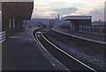
Burnley Central station
Originally called 'Burnley Bank Top', this was until the time of Beeching, a large and important station. Now it is served by just a single track line. There is, however, a booking office and a railwayman on duty here.
Image: © Dr Neil Clifton
Taken: 17 Aug 2009
0.01 miles
2
Burnley Central Railway Station
The line towards Colne.
Image: © JThomas
Taken: 2 Aug 2018
0.02 miles
3
Reindeer Hotel, Railway Street, Burnley
Image: © Alexander P Kapp
Taken: 6 Dec 2010
0.02 miles
4
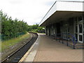
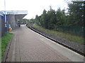
Burnley Central station
A platform view, looking towards Colne, (where the single line comes to a dead end: there are no points between Burnley and Colne, so no possibility of crossing trains).
Image: © Dr Neil Clifton
Taken: 17 Aug 2009
0.02 miles
5
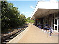
Burnley Central Station
Seen here in the fading light of a December afternoon, Central station is one of three that serve the town. One of the platforms was taken out of use in 1986 and the place had a forlorn air in this 1990 view; since then traces of the old platform have gone and the station now has a brighter, if basic and functional, feel - see Image
Image: © Stephen McKay
Taken: Unknown
0.02 miles
6
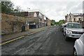
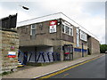
Railway Street
Passing Burnley Central railway station on the left. On the right is the former Adelphi pub which has been closed since 1997.
Image: © Bill Boaden
Taken: 31 May 2022
0.02 miles
7
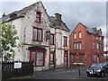
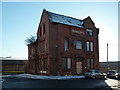
"The Adelphi" (Pub) Railway Street, Burnley, Lancashire
With "The Reindeer" (Pub) Railway Street on the right, the saga of these two derelict pubs drags on, to make matters worse this is the view when you arrive in Burnley by train.
Image: © Robert Wade
Taken: 23 Jun 2011
0.02 miles
8
Burnley Central railway station, Lancashire
Opened in 1848 by the East Lancashire Railway on its line from Accrington to Colne. With just one platform, this is probably one of the smallest "Central" stations in the country, although there used to be another platform to the right. View south west towards Burnley Barracks and Accrington.
Image: © Nigel Thompson
Taken: 25 Sep 2010
0.02 miles
10
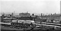
Burnley (Central) Station
View westward, towards Burnley Barracks and Accrington (to left); ex-Lancashire & Yorkshire main line, Preston/Manchester - Blackburn - Accrington - Burnley - Colne, called Bank Top until 10/44. The photograph was taken from a footbridge from Colne Road over the exchange sidings for traffic from the NCB Bank Hall colliery.
Image: © Ben Brooksbank
Taken: 22 Sep 1962
0.03 miles