IMAGES TAKEN NEAR TO
Barcroft Green, BURNLEY, BB10 4UD
Introduction
This page details the photographs taken nearby to Barcroft Green, BB10 4UD by members of the Geograph project.
The Geograph project started in 2005 with the aim of publishing, organising and preserving representative images for every square kilometre of Great Britain, Ireland and the Isle of Man.

There are currently over 7.5m images from over14,400 individuals and you can help contribute to the project by visiting https://www.geograph.org.uk
Image Map
Images are licensed for reuse under creativecommons.org/licenses/by-sa/2.0
Notes
- Clicking on the map will re-center to the selected point.
- The higher the marker number, the further away the image location is from the centre of the postcode.
Image Listing (37 Images Found)
Images are licensed for reuse under creativecommons.org/licenses/by-sa/2.0
Image
Details
Distance
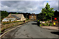
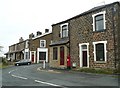
1
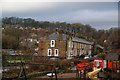
Row of terraced houses on Park Road
In the foreground is the RACA Park, provided by public subscription. However the park which is the destination of Park Road is Towneley Park.
Image: © Bill Boaden
Taken: 28 Dec 2010
0.03 miles
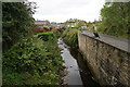
2
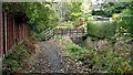
Burnley Way Footbridge
Crosses the River Calder to give access to Park Road
Image: © Kevin Waterhouse
Taken: 11 Oct 2022
0.06 miles
3
RACA Park, Walk Mill
The plaque on the stone reads:
"R.A.C.A. Park
The Recreation Area Cliviger Appeal & generous public donations provided this park with assistance from Burnley Borough Council.
Opened by councillor ARTHUR PARK 30th August 1997"
Image: © David Dixon
Taken: 7 Oct 2010
0.07 miles
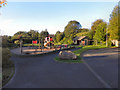
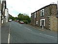
4
Park Road, Walk Mill
Road adopted by the Burnley Way long distance footpath
Image: © Chris Heaton
Taken: 7 Jun 2017
0.07 miles
5
The River Calder at Cliviger
Not a very big river considering the size of the valley it runs in.
Image: © Bill Boaden
Taken: 13 May 2017
0.07 miles
7
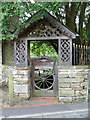
Ornate gate on Park Road, Walk Mill
Image: © Alexander P Kapp
Taken: 5 Jul 2012
0.10 miles
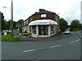
8
Former post office, Walk Mill, Cliviger
The OS map is not clear as to whether the post office was the refronted house with the pillar box outside or the former shop over the road.
Image: © Humphrey Bolton
Taken: 6 May 2010
0.10 miles
9
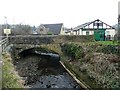
Cliviger Mill Bridge
The 1848 six-inch map has the caption 'Cliviger Mill (Corn)' but on the 1893 1:2500 map it was Cliviger Brewery (disused). The building with the green door was, or is on the site of, a smithy.
Image: © Humphrey Bolton
Taken: 3 Mar 2011
0.11 miles