IMAGES TAKEN NEAR TO
Salterford Lane, BURNLEY, BB10 4RY
Introduction
This page details the photographs taken nearby to Salterford Lane, BB10 4RY by members of the Geograph project.
The Geograph project started in 2005 with the aim of publishing, organising and preserving representative images for every square kilometre of Great Britain, Ireland and the Isle of Man.

There are currently over 7.5m images from over14,400 individuals and you can help contribute to the project by visiting https://www.geograph.org.uk
Image Map
Images are licensed for reuse under creativecommons.org/licenses/by-sa/2.0
Notes
- Clicking on the map will re-center to the selected point.
- The higher the marker number, the further away the image location is from the centre of the postcode.
Image Listing (24 Images Found)
Images are licensed for reuse under creativecommons.org/licenses/by-sa/2.0
Image
Details
Distance
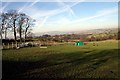
1
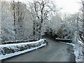
Salterford Bridge
Salterford Lane near Hurstwood
Image: © Kevin Rushton
Taken: 1 Jan 2002
0.03 miles
2
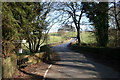
Salterford Lane
Salterford Bridge looking towards Hurstwood
Image: © Kevin Rushton
Taken: 10 Feb 2008
0.05 miles
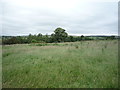
3
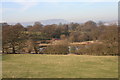
Salterford Trout Farm
Lakes made by the side of River Brun to breed fish
Image: © Kevin Rushton
Taken: 10 Feb 2008
0.11 miles
4
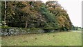
Estate Walling to Ormerod House
The substantial walling encloses the River Brun within the private estate, so this path along the valley has no view of the river.
Image: © Kevin Waterhouse
Taken: 16 Oct 2022
0.11 miles
5
Salterford Lane
View towards the trout farm near the bridge
Image: © Kevin Rushton
Taken: 10 Feb 2008
0.16 miles
6
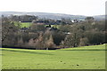
Ormerod House
View of the buildings amongst the woods at Ormerod House the main hall in the grounds had to be demolished in 1947 because the coal seam below had been undermined
Image: © Kevin Rushton
Taken: 14 Jan 2007
0.17 miles
8
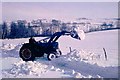
Snow clearance - Ormerod House driveway
The winter of 1962 - 63 was very severe with blizzard conditions forming deep snow drifts
Image: © Richard Johnson
Taken: Unknown
0.18 miles
9
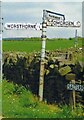
Direction Sign ? Signpost south of Worsthorne
Located on the southeast side of the T junction of Ormerod Street, Salterford Lane and Hurstwood Lane, south of Worsthorne in Worsthorne with Hurstwood parish. 3 arms, 1 worboys and lost finial. For a photo after restoration by Duncan Armstrong see https://www.geograph.org.uk/photo/6523056.
Milestone Society National ID: LA_SD8731
Image: © D Armstrong
Taken: Unknown
0.18 miles
10
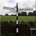
Direction Sign ? Signpost south of Worsthorne
Located on the southeast side of the T junction of Ormerod Street, Salterford Lane and Hurstwood Lane, south of Worsthorne in Worsthorne with Hurstwood parish. 3 arms and cup & bell finial. For a photo before restoration by Duncan Armstrong see https://www.geograph.org.uk/photo/6687857.
Milestone Society National ID: LA_SD8731
Image: © M Strangways
Taken: 21 Aug 2019
0.18 miles