IMAGES TAKEN NEAR TO
Gorple Road, BURNLEY, BB10 3NN
Introduction
This page details the photographs taken nearby to Gorple Road, BB10 3NN by members of the Geograph project.
The Geograph project started in 2005 with the aim of publishing, organising and preserving representative images for every square kilometre of Great Britain, Ireland and the Isle of Man.

There are currently over 7.5m images from over14,400 individuals and you can help contribute to the project by visiting https://www.geograph.org.uk
Image Map
Images are licensed for reuse under creativecommons.org/licenses/by-sa/2.0
Notes
- Clicking on the map will re-center to the selected point.
- The higher the marker number, the further away the image location is from the centre of the postcode.
Image Listing (50 Images Found)
Images are licensed for reuse under creativecommons.org/licenses/by-sa/2.0
Image
Details
Distance
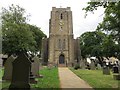
1
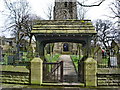
St John the Evangelist Church, Worsthorne, Lych gate
Image: © Alexander P Kapp
Taken: 11 Apr 2008
0.04 miles
2
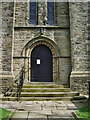
St John the Evangelist Church, Worsthorne, Doorway
Image: © Alexander P Kapp
Taken: 11 Apr 2008
0.05 miles
3
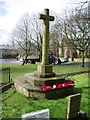
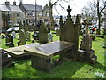
War memorial, Worsthorne
To be found in the south west corner of the graveyard
Image: © Alexander P Kapp
Taken: 11 Apr 2008
0.05 miles
5
St John's Church, Worsthorne
This is at the high end of the ecclesiastical spectrum. The church is seen from Church Square.
Image: © Bill Boaden
Taken: 17 Dec 2010
0.06 miles
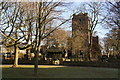
6
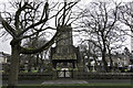
The Church of St John the Evangelist and part of the graveyard at Worsthorne
Viewed from the west.
Image: © Peter Wood
Taken: 8 Aug 2018
0.06 miles
7
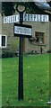
Direction Sign ? Signpost in Worsthorne
Located in Worsthorne on the northeast side of the junction of Gorple Road and Extwistle Road in Worsthorne with Hurstwood parish. 3 arms and annulus finial. See also https://www.geograph.org.uk/photo/2295567.
Milestone Society National ID: LA_SD8732B
Image: © D Armstrong
Taken: Unknown
0.06 miles
8
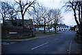
Winter evening at Church Square
This is the approach from Extwistle Road.
Image: © Bill Boaden
Taken: 17 Dec 2010
0.06 miles
9
St John the Evangelist Church, Worsthorne, Graveyard
Image: © Alexander P Kapp
Taken: 11 Apr 2008
0.06 miles
10
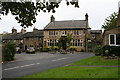
The 'Crooked Billet', Worsthorne, Lancashire
Slightly away from the main square at the end of Water Street, this may well be the pub. of choice for those who have always lived in Worsthorne. Lovely floral decorations outside. Two cask ales...
Image: © Dr Neil Clifton
Taken: 8 Sep 2007
0.07 miles