IMAGES TAKEN NEAR TO
Brownside Road, BURNLEY, BB10 3LW
Introduction
This page details the photographs taken nearby to Brownside Road, BB10 3LW by members of the Geograph project.
The Geograph project started in 2005 with the aim of publishing, organising and preserving representative images for every square kilometre of Great Britain, Ireland and the Isle of Man.

There are currently over 7.5m images from over14,400 individuals and you can help contribute to the project by visiting https://www.geograph.org.uk
Image Map
Images are licensed for reuse under creativecommons.org/licenses/by-sa/2.0
Notes
- Clicking on the map will re-center to the selected point.
- The higher the marker number, the further away the image location is from the centre of the postcode.
Image Listing (10 Images Found)
Images are licensed for reuse under creativecommons.org/licenses/by-sa/2.0
Image
Details
Distance
1
Lower Cote Cottage
To the left of the cottage is Higher Cote Cottage
Image: © Kevin Rushton
Taken: 10 Feb 2008
0.01 miles
2
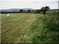
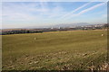
A Field to the North of Brownside
A footpath runs to the side of this field affording great views towards Pendle Hill.
Image: © Chris Heaton
Taken: 7 Oct 2009
0.06 miles
3
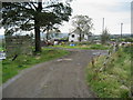
Heckenhurst
Dwelling near Brownside on the outskirts of Burnley, undergoing some renovation.
Image: © Chris Heaton
Taken: 7 Oct 2009
0.12 miles
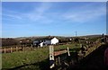
4
Heckenhurst Farm
Behind the wall to the left was the reservoirs which have now been flattened to make way for pasture land for the farmers sheep
Image: © Kevin Rushton
Taken: 10 Feb 2008
0.12 miles
5
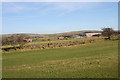
Heckenhurst Reservoir Site
Before the water treatment plant was built on Brownside Road there were three reservoirs here for water supply for the surrounding district.
Image: © Kevin Rushton
Taken: 10 Feb 2008
0.13 miles
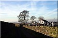
6
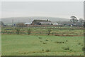
Heckenhurst Farm
Viewed from Rowley Lane on a slightly misty day. Wasnop Edge is in the background, the beginning of the higher Pennines.
Image: © Bill Boaden
Taken: 12 Jan 2022
0.16 miles
7
Worsthorne Water Treatment Plant
View of the new treatment works from the old Heckenhurst reservoir site
Image: © Kevin Rushton
Taken: 10 Feb 2008
0.19 miles
8
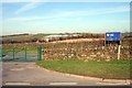
Brownside Road Worsthorne
Entrance to Worsthorne Water Treatment Works
Image: © Kevin Rushton
Taken: 10 Feb 2008
0.21 miles
9

Reservoir valve house remains
This was for the Heckenhurst reservoirs of which only the substantial boundary wall remains. The view of this section of the wall has the corner stones for the valve house and a blocked window.
Image: © Kevin Waterhouse
Taken: 4 Mar 2023
0.21 miles
10
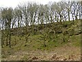
Rocky outcrops near Swinden Water
The valley starts to have rocky outcrops as it narrows at this point north of Wood Hey Farm, which is behind the camera. The Burnley Way follows this valley.
Image: © Kevin Waterhouse
Taken: 4 Mar 2023
0.22 miles