IMAGES TAKEN NEAR TO
Orchard Close, WINCANTON, BA9 9RL
Introduction
This page details the photographs taken nearby to Orchard Close, BA9 9RL by members of the Geograph project.
The Geograph project started in 2005 with the aim of publishing, organising and preserving representative images for every square kilometre of Great Britain, Ireland and the Isle of Man.

There are currently over 7.5m images from over14,400 individuals and you can help contribute to the project by visiting https://www.geograph.org.uk
Image Map
Images are licensed for reuse under creativecommons.org/licenses/by-sa/2.0
Notes
- Clicking on the map will re-center to the selected point.
- The higher the marker number, the further away the image location is from the centre of the postcode.
Image Listing (15 Images Found)
Images are licensed for reuse under creativecommons.org/licenses/by-sa/2.0
Image
Details
Distance
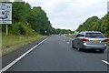
1
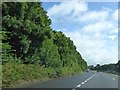
Lay-by on A303 Wincanton bypass
A lay-by on the eastbound carriageway to the south of Wincanton
Image: © David Smith
Taken: 10 Aug 2014
0.09 miles
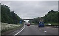
4
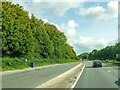
Wincanton : A303
Heading east on the A303.
Image: © Lewis Clarke
Taken: 12 Sep 2020
0.11 miles
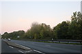
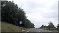
5
A303 heading west
Bypassing Wincanton, but the sign partly seen on the left extols the virtues of turning off into the town.
Image: © Robin Webster
Taken: 7 Sep 2019
0.11 miles
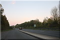
8
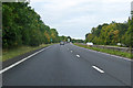
A303 heading west
Bypassing Wincanton, with a junction accessing the town ahead.
Image: © Robin Webster
Taken: 7 Sep 2019
0.18 miles
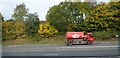
10
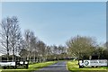
Wincanton: Somerset and Dorset Animal Rescue
Image: © Michael Garlick
Taken: 1 Apr 2019
0.22 miles