IMAGES TAKEN NEAR TO
Marsh, WINCANTON, BA9 9QZ
Introduction
This page details the photographs taken nearby to BA9 9QZ by members of the Geograph project.
The Geograph project started in 2005 with the aim of publishing, organising and preserving representative images for every square kilometre of Great Britain, Ireland and the Isle of Man.

There are currently over 7.5m images from over14,400 individuals and you can help contribute to the project by visiting https://www.geograph.org.uk
Image Map
Images are licensed for reuse under creativecommons.org/licenses/by-sa/2.0
Notes
- Clicking on the map will re-center to the selected point.
- The higher the marker number, the further away the image location is from the centre of the postcode.
Image Listing (2 Images Found)
Images are licensed for reuse under creativecommons.org/licenses/by-sa/2.0
Image
Details
Distance
2
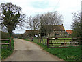
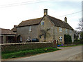
Marsh Court
According to Somerset County Council, Marsh Court, was rebuilt in 1661 probably from the ruin of the former house. A part of a moat still remains, and this is marked on the OS map. The present house is 17th century and is Grade II listed.
Image: © Mike Searle
Taken: 11 Apr 2007
0.20 miles