IMAGES TAKEN NEAR TO
Balsam Lane, WINCANTON, BA9 9HZ
Introduction
This page details the photographs taken nearby to Balsam Lane, BA9 9HZ by members of the Geograph project.
The Geograph project started in 2005 with the aim of publishing, organising and preserving representative images for every square kilometre of Great Britain, Ireland and the Isle of Man.

There are currently over 7.5m images from over14,400 individuals and you can help contribute to the project by visiting https://www.geograph.org.uk
Image Map
Images are licensed for reuse under creativecommons.org/licenses/by-sa/2.0
Notes
- Clicking on the map will re-center to the selected point.
- The higher the marker number, the further away the image location is from the centre of the postcode.
Image Listing (21 Images Found)
Images are licensed for reuse under creativecommons.org/licenses/by-sa/2.0
Image
Details
Distance
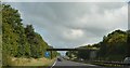
3
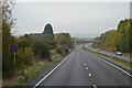
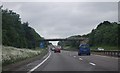
South Somerset : The A303
The A303 heading past Wincanton in South Somerset.
Image: © Lewis Clarke
Taken: 23 Aug 2012
0.06 miles
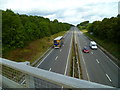
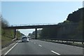
4
A303 heading west
Bypassing Wincanton, the bridge ahead carries Common Road.
Image: © Robin Webster
Taken: 7 Sep 2019
0.09 miles
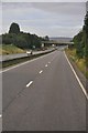
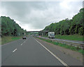
5
Bridge over A303 south-east of Wincanton
The bridge carries a minor road; it crosses the north-south gridline
Image: © David Smith
Taken: 13 Apr 2012
0.10 miles
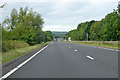
8
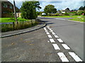
The Orange Way in Dorset and Somerset (264)
The route carries on up Common Road.
Image: © Shazz
Taken: 24 Sep 2012
0.12 miles
10
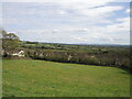
A view held for perpetuity
Wincanton is a relatively small town and in the past was much more involved in rural matters. Marking when a water supply was brought to it in the late 1800s, Samuel Deanesly is remembered by this spot. Bean Close has been given to the feoffees of the town in memoriam in 1927 so that this view will be enjoyed by all. It is rather more significant these days as just down the road a lot of land has been claimed for a small housing development.
It also happens to provide a view over a wartime disaster. In 1944 an American B-17 bomber crashed near Snagg Farm, some 1km (5/8 mile) from here. See Image]
Image: © Neil Owen
Taken: 18 Apr 2024
0.17 miles