IMAGES TAKEN NEAR TO
Shaftesbury Road, TEMPLECOMBE, BA8 0TE
Introduction
This page details the photographs taken nearby to Shaftesbury Road, BA8 0TE by members of the Geograph project.
The Geograph project started in 2005 with the aim of publishing, organising and preserving representative images for every square kilometre of Great Britain, Ireland and the Isle of Man.

There are currently over 7.5m images from over14,400 individuals and you can help contribute to the project by visiting https://www.geograph.org.uk
Image Map
Images are licensed for reuse under creativecommons.org/licenses/by-sa/2.0
Notes
- Clicking on the map will re-center to the selected point.
- The higher the marker number, the further away the image location is from the centre of the postcode.
Image Listing (8 Images Found)
Images are licensed for reuse under creativecommons.org/licenses/by-sa/2.0
Image
Details
Distance
1
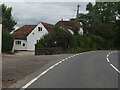
The White House, A30 Shaftesbury Road
Possibly a former Toll House serving the Sherborne Turnpike Trust in the 19ᵗʰ C.
There is a former Toll House nearby to the West Image that served a different Turnpike Trust.
Milestone Society National ID: DO.KIN
Image: © Mr Red
Taken: 4 Aug 2023
0.00 miles
2
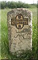
Old Milestone by the A30, east of Bow Bridge
Metal plate attached to stone post by the A30, in parish of KINGTON MAGNA (NORTH DORSET District), East of Bow Bridge; 2m back from road, opposite Bow Bridge Cottage (tollhouse?), by the road, on South side of road. Dorset 3 and 4 (iron plated), erected by the Sherborne turnpike trust in the 19th century.
Inscription reads:-
8
SHERBORNE
SHASTON
8
Carved benchmark centre front.
Milestone Society National ID: DO_SBSH08.
Image: © J Tybjerg
Taken: 9 Oct 2002
0.02 miles
3
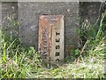
Old Boundary Marker by the A30, Bow Bridge, Henstridge parish
County Boundary Marker by the A30, in parish of Henstridge (South Somerset District), East end of Bow Bridge, by North side of road.
Inscription reads:-
: SOMERSET : : BOUNDARY / 1909 : : DORSET :
Surveyed
Milestone Society National ID: SO_SSDO01cb
Image: © Milestone Society
Taken: Unknown
0.15 miles
4
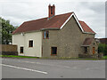
Bow Bridge Cottage, A30 Shaftesbury Road
Possibly a former Toll House, or modern restoration attempt on the foundations.
This location was the Bow TP as labelled in the OS drawing of 1808 ( https://britishlibrary.oldmapsonline.org/compare#666931988205 ) when there was a bridge across Bow Brook.
It would have served the Crewkerne Turnpike Trust in the 19ᵗʰ C.
Milestone Society National ID: SO.HEN
Image: © Mr Red
Taken: 4 Aug 2023
0.16 miles
7
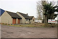
House at Jenkins Marine
This house occupies the front of a plot on the industrial estate of which the main industrial building belongs to Jenkins Marine a specialised Workboats, Barges and Dredging Contractor whose headquarters are in Poole
Image: © Nigel Mykura
Taken: 26 Jan 2017
0.23 miles