IMAGES TAKEN NEAR TO
South Cheriton, TEMPLECOMBE, BA8 0BG
Introduction
This page details the photographs taken nearby to BA8 0BG by members of the Geograph project.
The Geograph project started in 2005 with the aim of publishing, organising and preserving representative images for every square kilometre of Great Britain, Ireland and the Isle of Man.

There are currently over 7.5m images from over14,400 individuals and you can help contribute to the project by visiting https://www.geograph.org.uk
Image Map
Images are licensed for reuse under creativecommons.org/licenses/by-sa/2.0
Notes
- Clicking on the map will re-center to the selected point.
- The higher the marker number, the further away the image location is from the centre of the postcode.
Image Listing (18 Images Found)
Images are licensed for reuse under creativecommons.org/licenses/by-sa/2.0
Image
Details
Distance
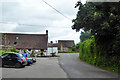
1
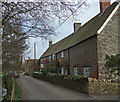
Horse and rider in Cheriton Street
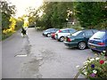
The car park is attached to "The White Horse".
Image: © Shazz
Taken: 27 Sep 2012
0.04 miles
2
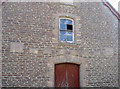
Temperance Hall
Proudly stating the hall is both a Victorian memorial, but also open to all shades of the religious spectrum. The hall does not appear to be in much use now, particularly as a temperance meeting place.
Image: © Neil Owen
Taken: 14 Sep 2016
0.05 miles
3
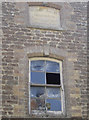
Initials on the hall
The Unsectarian Temperance Hall in South Cheriton was built during the Victorian Jubilee. The doors are perhaps modern but the many stone tablets in the wall have initials - presumably the important and worthy patrons in the village.
Image: © Neil Owen
Taken: 14 Sep 2016
0.05 miles
4
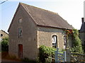
Unsectarian Temperance Hall
South Cheriton is a small village even these days, but in 1887 it opened a Temperance Hall - a venue where alcohol was strictly abstained, as was the movement in Victorian times. The Unsectarian aspect must have appealed to the various religious groups in the area.
Image: © Neil Owen
Taken: 14 Sep 2016
0.05 miles
6
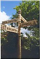
Direction Sign - Signpost on the A357 in South Cheriton
Pyramid finial - 4 arms; Somerset SCC pyramid by the A357, in parish of Horsington (South Somerset District), in South Cheriton on the southeast side of the staggered crossroads of the A357 Higher Road, Cabbage Lane and Cheriton Street.
surveyed
Milestone Society National ID: SO_ST6924
Image: © Milestone Society
Taken: Unknown
0.07 miles
7
The National Byway runs through South Cheriton
Although the brown colouration appears to have lost some of its richness, the route is part of the extensive project to allow cyclists to enjoy the countryside.
Image: © Neil Owen
Taken: 14 Sep 2016
0.07 miles
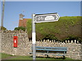
9
Cabbage Lane meets the A357
Looking from the car park at the back of the White Horse.
Image: © Robin Webster
Taken: 4 Jun 2017
0.08 miles
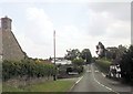
10
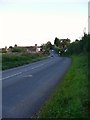
The A357 through South Cheriton looking south
Image: © Shazz
Taken: 27 Sep 2012
0.08 miles