IMAGES TAKEN NEAR TO
Lower Ansford, CASTLE CARY, BA7 7JY
Introduction
This page details the photographs taken nearby to Lower Ansford, BA7 7JY by members of the Geograph project.
The Geograph project started in 2005 with the aim of publishing, organising and preserving representative images for every square kilometre of Great Britain, Ireland and the Isle of Man.

There are currently over 7.5m images from over14,400 individuals and you can help contribute to the project by visiting https://www.geograph.org.uk
Image Map
Images are licensed for reuse under creativecommons.org/licenses/by-sa/2.0
Notes
- Clicking on the map will re-center to the selected point.
- The higher the marker number, the further away the image location is from the centre of the postcode.
Image Listing (45 Images Found)
Images are licensed for reuse under creativecommons.org/licenses/by-sa/2.0
Image
Details
Distance
1
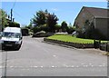
Lower Ansford, Ansford
Viewed across the A371 Ansford Hill.
Image: © Jaggery
Taken: 4 Jun 2015
0.03 miles

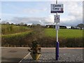
3
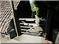
Gate to a footpath to Castle Cary railway station
From the A371 Ansford Hill, the path extends for about 320 metres to Castle Cary railway station.
Image: © Jaggery
Taken: 4 Jun 2015
0.05 miles
4
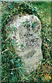
Old Milestone by the A371, Ansford Hill, Ansford Parish
Stone post (plate lost) by the A371, in parish of ANSFORD (SOUTH SOMERSET District), Ansford Hill, junction with Lower Ansford, by driveway on roadside verge at junction, on South side of road. LSCC iron plate, erected by the Shepton Mallet turnpike trust in the 19th century.
Inscription illegible.
Milestone Society National ID: SO_CCWC.
Image: © M Dixon
Taken: 1 Dec 2001
0.05 miles
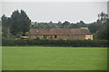
6
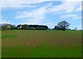
Hillcrest Farm
View up the hill looking south from Castle Cary station.
Image: © Nigel Mykura
Taken: 6 Apr 2011
0.07 miles


9
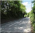
Ansford Hill, Ansford
The A371 Ansford Hill descends from Higher Ansford towards Lower Ansford.
Image: © Jaggery
Taken: 4 Jun 2015
0.09 miles
10
Castle Cary Station
View south from the station platform. Castle Cary station is on the north side of the town. This area is known as Ansford and is close to Ansford bridge over the river Brue. The houses in the distance are on the A371 on the northern edge of Ansford.
Image: © Nigel Mykura
Taken: 10 Mar 2010
0.10 miles