IMAGES TAKEN NEAR TO
Higher Ansford, CASTLE CARY, BA7 7JQ
Introduction
This page details the photographs taken nearby to Higher Ansford, BA7 7JQ by members of the Geograph project.
The Geograph project started in 2005 with the aim of publishing, organising and preserving representative images for every square kilometre of Great Britain, Ireland and the Isle of Man.

There are currently over 7.5m images from over14,400 individuals and you can help contribute to the project by visiting https://www.geograph.org.uk
Image Map
Images are licensed for reuse under creativecommons.org/licenses/by-sa/2.0
Notes
- Clicking on the map will re-center to the selected point.
- The higher the marker number, the further away the image location is from the centre of the postcode.
Image Listing (36 Images Found)
Images are licensed for reuse under creativecommons.org/licenses/by-sa/2.0
Image
Details
Distance
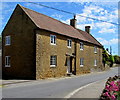
1
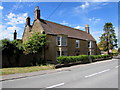
Ansford Lodge, Higher Ansford
Viewed across the A371 Ansford Hill, near the Churchfield Drive and Maggs Lane junctions.
Probably dating from the late 18th century, Grade II* Listed (the second-highest category) in 1961.
Image: © Jaggery
Taken: 4 Jun 2015
0.01 miles

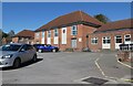
3
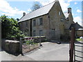
Former Hillcrest School, Higher Ansford
Fenced off in early June 2015. The 18th century building was formerly a school, earlier a rectory.
Image: © Jaggery
Taken: 4 Jun 2015
0.04 miles
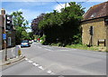
4

Zebra crossing, Ansford Hill, Ansford
Across the A371, here named Ansford Hill, near the Maggs Lane http://www.geograph.org.uk/photo/4509011 junction.
Image: © Jaggery
Taken: 4 Jun 2015
0.06 miles
5

Ansford Silver Jubilee Gardens
On the west side of the A371 Ansford Hill, opposite this http://www.geograph.org.uk/photo/4509042 zebra crossing. The inscription is
ANSFORD Jubilee Gardens 1977.
1977 was Silver Jubilee Year, marking the 25th anniversary
of the accession of Queen Elizabeth II on February 6th 1952.
Image: © Jaggery
Taken: 4 Jun 2015
0.06 miles
6

Churchfield Drive, Ansford
On the west side of the A371, opposite Maggs Lane. http://www.geograph.org.uk/photo/4509011
Image: © Jaggery
Taken: 4 Jun 2015
0.07 miles
7
Top of Ansford Hill, Higher Ansford
Viewed from the corner of Ansford Road and Cumnock Road.
The A371 Ansford Hill descends from Higher Ansford towards Lower Ansford.
Image: © Jaggery
Taken: 4 Jun 2015
0.07 miles
8
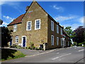
The Yardarm, Higher Ansford
Former inn on the corner of Ansford Road and the A371 Ansford Hill.
Grade II listed in 1961 as the Old Ansford Inn.
Image: © Jaggery
Taken: 4 Jun 2015
0.08 miles
10
Grade II listed former barn in Higher Ansford
House formerly an Ansford Farm barn, possibly built in the 18th century.
Image: © Jaggery
Taken: 4 Jun 2015
0.09 miles