
IMAGES TAKEN NEAR TO
Ancastle Terrace, CASTLE CARY, BA7 7HU
Introduction
This page details the photographs taken nearby to Ancastle Terrace, BA7 7HU by members of the Geograph project.
The Geograph project started in 2005 with the aim of publishing, organising and preserving representative images for every square kilometre of Great Britain, Ireland and the Isle of Man.

There are currently over 7.5m images from over14,400 individuals and you can help contribute to the project by visiting https://www.geograph.org.uk
Image Map
Images are licensed for reuse under creativecommons.org/licenses/by-sa/2.0
Notes
- Clicking on the map will re-center to the selected point.
- The higher the marker number, the further away the image location is from the centre of the postcode.
Image Listing (51 Images Found)
Images are licensed for reuse under creativecommons.org/licenses/by-sa/2.0
Image
Details
Distance
1
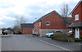
New Houses near Cary Hill
This new residential cul-de-sac is just off Cary Hill , the A37, on the east side of Castle Cary
Image: © Nigel Mykura
Taken: 14 Mar 2018
0.04 miles
2

Tudor style rooftops in Castle Cary
Distinctive tudor style chimneys, although only built in 1877 by John Boyd, for workers at his horse-hair factory in the town. Listed Grade II. See http://www.britishlistedbuildings.co.uk/en-490828-cumnock-terrace-including-front-garden-w for more information
Image: © Graham Horn
Taken: 4 May 2007
0.07 miles
3
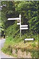
Direction Sign - Signpost on the A371 in Castle Cary
Pyramid finial - 5 arms; Somerset SCC pyramid by the A371, in parish of Castle Cary (South Somerset District), on the south side of the crossroads of the A371 Vary Road, Cumnock Road, North Street and Wyke Road.
surveyed
Milestone Society National ID: SO_ST6432
Image: © J Dowding
Taken: Unknown
0.08 miles
6
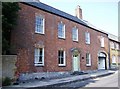
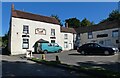
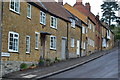
Douglas Macmillan's house
Douglas Macmillan (founder of Macmillan Cancer Relief now Macmillan Cancer Support) was born nearby and grew up in this house from the age of six. A close up of the plaque is seen here Image The Macmillan Way long distance path (set up to help with the work of the charity) enters the town just a few yards away. The house is unusually made of brick, a change from the many stone villages that the Macmillan Way passes through.
I am grateful to Douglas Macmillan's great, great niece for correcting some of the information above.
Image: © Graham Horn
Taken: 4 May 2007
0.11 miles
7
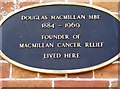
Douglas Macmillan plaque
Close up of the plaque on the wall of this house Image] in Castle Cary High Street. Although it does not specifically say so, he was born nearby, grew up in this house from the age of six, and went to school in nearby Bruton.
I am grateful to Douglas Macmillan's great, great niece for providing me with this information.
Image: © Graham Horn
Taken: 4 May 2007
0.13 miles
8
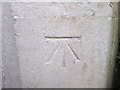
Ordnance Survey Cut Mark
This OS cut mark can be found on the east face of the Methodist Chapel on Upper High Street. It marks a point 93.915m above mean sea level.
Image: © Adrian Dust
Taken: 19 Nov 2014
0.14 miles
9
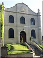
Castle Cary methodist chapel
In High Street. Opposite is the house of Douglas Macmillan, founder of Macmillan Cancer Support.
Image: © Graham Horn
Taken: 4 May 2007
0.15 miles
10

Coombe Close, Castle Cary
On the east side of Ansford Road.
Image: © Jaggery
Taken: 4 Jun 2015
0.15 miles