IMAGES TAKEN NEAR TO
Victoria Gardens, CASTLE CARY, BA7 7DJ
Introduction
This page details the photographs taken nearby to Victoria Gardens, BA7 7DJ by members of the Geograph project.
The Geograph project started in 2005 with the aim of publishing, organising and preserving representative images for every square kilometre of Great Britain, Ireland and the Isle of Man.

There are currently over 7.5m images from over14,400 individuals and you can help contribute to the project by visiting https://www.geograph.org.uk
Image Map
Images are licensed for reuse under creativecommons.org/licenses/by-sa/2.0
Notes
- Clicking on the map will re-center to the selected point.
- The higher the marker number, the further away the image location is from the centre of the postcode.
Image Listing (112 Images Found)
Images are licensed for reuse under creativecommons.org/licenses/by-sa/2.0
Image
Details
Distance
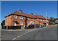
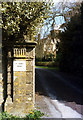
2
Victoria Park, Castle Cary
Viewed across Station Road.
Image: © Jaggery
Taken: 4 Jun 2015
0.07 miles
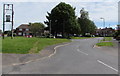
3
Castle Cary : Victoria Park
A road off Station Road.
Image: © Lewis Clarke
Taken: 19 Jun 2023
0.08 miles
4
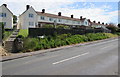
Long row of West Park houses, Castle Cary
Viewed across Station Road.
Image: © Jaggery
Taken: 4 Jun 2015
0.09 miles
5
St John's Priory, Castle Cary
Secluded, but almost in the centre of Castle Cary, stands St John's Priory. This was the convent home of the Sisters of Jesus Crucified.
Image: © Peter Kazmierczak
Taken: Unknown
0.10 miles
6
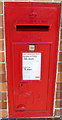
King George V postbox, Station Road, Castle Cary
In a brick pillar here. http://www.geograph.org.uk/photo/4510519
Image: © Jaggery
Taken: 4 Jun 2015
0.12 miles
7
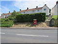
Postbox in a brick pillar, Station Road, Castle Cary
The red box http://www.geograph.org.uk/photo/4510515 is from the reign of King George V (1910-1936).
Image: © Jaggery
Taken: 4 Jun 2015
0.12 miles
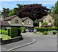
8

Lower level and higher level houses, Station Road, Castle Cary
Dunnes Terrace http://www.geograph.org.uk/photo/4514557 is on the left.
Image: © Jaggery
Taken: 4 Jun 2015
0.13 miles
9
Kingsacre Castle Cary
Cul-de-sac on the north side of Priory Close.
Image: © Jaggery
Taken: 4 Jun 2015
0.13 miles
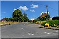
10
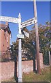
Old Direction Sign - Signpost by the B3152, Station Road, Castle Cary
Tall pyramid finial - 3 arms; Somerset SCC square end by the B3152, in parish of Castle Cary (South Somerset District), Torbay Road junction with Station Road.
Surveyed
Milestone Society National ID: SO_ST6332B
Image: © Milestone Society
Taken: Unknown
0.13 miles