IMAGES TAKEN NEAR TO
Westhay, GLASTONBURY, BA6 9TX
Introduction
This page details the photographs taken nearby to BA6 9TX by members of the Geograph project.
The Geograph project started in 2005 with the aim of publishing, organising and preserving representative images for every square kilometre of Great Britain, Ireland and the Isle of Man.

There are currently over 7.5m images from over14,400 individuals and you can help contribute to the project by visiting https://www.geograph.org.uk
Image Map
Images are licensed for reuse under creativecommons.org/licenses/by-sa/2.0
Notes
- Clicking on the map will re-center to the selected point.
- The higher the marker number, the further away the image location is from the centre of the postcode.
Image Listing (7 Images Found)
Images are licensed for reuse under creativecommons.org/licenses/by-sa/2.0
Image
Details
Distance
3
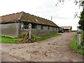
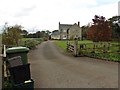
Farm
Blue barns at Peacock Farm. This farm specializes in Ruby Red Devon cattle.
Image: © Adrian and Janet Quantock
Taken: 5 Feb 2006
0.08 miles
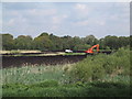
7
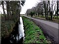
Rhyne and Road , Westhay Moor
This rhyne runs along Westhay Moor Drove. This is close to its junction with London Drove just east of Peacock Farm.
Image: © Nigel Mykura
Taken: 6 Feb 2011
0.19 miles