IMAGES TAKEN NEAR TO
Thomas Way Industrial Estate, GLASTONBURY, BA6 9LU
Introduction
This page details the photographs taken nearby to Thomas Way Industrial Estate, BA6 9LU by members of the Geograph project.
The Geograph project started in 2005 with the aim of publishing, organising and preserving representative images for every square kilometre of Great Britain, Ireland and the Isle of Man.

There are currently over 7.5m images from over14,400 individuals and you can help contribute to the project by visiting https://www.geograph.org.uk
Image Map
Images are licensed for reuse under creativecommons.org/licenses/by-sa/2.0
Notes
- Clicking on the map will re-center to the selected point.
- The higher the marker number, the further away the image location is from the centre of the postcode.
Image Listing (31 Images Found)
Images are licensed for reuse under creativecommons.org/licenses/by-sa/2.0
Image
Details
Distance
1
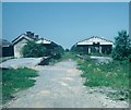
Glastonbury and Street Railway Station
Taken in June, 1979, this photo shows the remains of the station looking towards Highbridge on the Somerset & Dorset railway line which closed to passengers in March, 1966. The whole area is now occupied by an industrial estate, the postcode being BA6 9LU.
Image: © David Hillas
Taken: 11 Jun 1979
0.04 miles
2

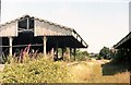
Magnificent Tree by the Saw Mill
I am not sure what species this evergreen is but it has been here for more than a week or two. It stands opposite the saw mill on Porchestall Drove. See Image for evidence of its age.
Image: © Glyn Baker
Taken: 21 Dec 2019
0.05 miles
3

Redundant Iron Bracket
There were a number of other iron artefacts grown into the Image
Image: © Glyn Baker
Taken: 21 Dec 2019
0.06 miles
4
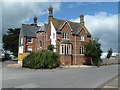
Glastonbury's railway past.
I believe this is the building listed in one of my reference works as a red brick building that was once the Railway Hotel and later became offices of the Somerset & Dorset Railway.
Image: © Chris Allen
Taken: 30 Jun 2012
0.06 miles
5
Glastonbury Station
Glastonbury railway station looking towards Wells & West Pennard.
Image: © Ray Durrant
Taken: 25 Jul 1981
0.08 miles
6

Former offices of the Somerset and Dorset railway
Buried in a modern factory estate, this fine building was once owned by the Somerset and Dorset Railway. It now has a new lease of life, functioning as offices for the nearby timber company.
Image: © Richard Bird
Taken: 20 Jun 2011
0.08 miles

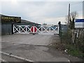
8

A railway relic on the Park Farm industrial estate
Glastonbury formerly had a railway station at Park Farm. There was a track with level crossing where this road crossed the line at the station and the crossing gates remain by the industrial unit
Image: © David Smith
Taken: 16 Nov 2017
0.09 miles
9
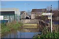
Mill Stream and Sharpham Sign
I wouldn't fancy the cost of flood insurance around here!
Image: © Glyn Baker
Taken: 21 Dec 2019
0.10 miles
10
Dye House Crossing
At least the gates are still in use even if the railway is not.
Image: © Bill Nicholls
Taken: 14 Apr 2012
0.10 miles