IMAGES TAKEN NEAR TO
Butleigh Wootton, GLASTONBURY, BA6 8TY
Introduction
This page details the photographs taken nearby to BA6 8TY by members of the Geograph project.
The Geograph project started in 2005 with the aim of publishing, organising and preserving representative images for every square kilometre of Great Britain, Ireland and the Isle of Man.

There are currently over 7.5m images from over14,400 individuals and you can help contribute to the project by visiting https://www.geograph.org.uk
Image Map
Images are licensed for reuse under creativecommons.org/licenses/by-sa/2.0
Notes
- Clicking on the map will re-center to the selected point.
- The higher the marker number, the further away the image location is from the centre of the postcode.
Image Listing (8 Images Found)
Images are licensed for reuse under creativecommons.org/licenses/by-sa/2.0
Image
Details
Distance
2
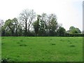
Small field, Butleigh Wootton
One of the many small fields which are often found around Somerset villages. Beyond the hedge is an orchard - very important!
Image: © Richard Webb
Taken: 21 Apr 2011
0.05 miles
5
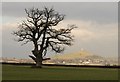
Oak near Butleigh Wootton
A venerable tree in mid-field on the north side of Back Lane, with a view to Image
Image: © Derek Harper
Taken: 12 Feb 2010
0.15 miles
6

Glastonbury Tor from the south
Taken from almost the centre of the grid square, looking across the flat Somerset Levels
Image: © Claire Ward
Taken: 18 Mar 2005
0.15 miles
7
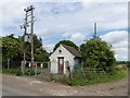
Electricity sub-station, Butleigh Wootton
Image: © Roger Cornfoot
Taken: 7 Jun 2017
0.18 miles
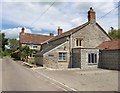
8
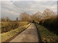
Back Lane, Butleigh Wootton
Running parallel to Wootton Street, which contains more of the buildings in this small village.
Image: © Derek Harper
Taken: 12 Feb 2010
0.23 miles