IMAGES TAKEN NEAR TO
Butleigh, GLASTONBURY, BA6 8TD
Introduction
This page details the photographs taken nearby to BA6 8TD by members of the Geograph project.
The Geograph project started in 2005 with the aim of publishing, organising and preserving representative images for every square kilometre of Great Britain, Ireland and the Isle of Man.

There are currently over 7.5m images from over14,400 individuals and you can help contribute to the project by visiting https://www.geograph.org.uk
Image Map
Images are licensed for reuse under creativecommons.org/licenses/by-sa/2.0
Notes
- Clicking on the map will re-center to the selected point.
- The higher the marker number, the further away the image location is from the centre of the postcode.
Image Listing (50 Images Found)
Images are licensed for reuse under creativecommons.org/licenses/by-sa/2.0
Image
Details
Distance
1
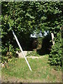
Taken a bit of a bash
The footpath sign has been the victim of some wayward wayfarers, sadly. Beyond is an odd stone stile - it appears that one standing slab has been lost and so the gap negates the stile's raison d'être.
Image: © Neil Owen
Taken: 12 Jul 2020
0.06 miles
2

A sun-kissed flag
An unusual palette of colours on this Union Jack.
Image: © Neil Owen
Taken: 12 Jul 2020
0.11 miles

4
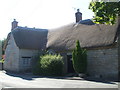
Sycamore Cottage
Like many homes in Butleigh this one has a fine thatched roof. It is originally a fifteenth century home for a well-to-do owner with an open hall and fire. Later occupants made changes in the sixteenth and eighteenth centuries, but the house was recently a healing centre.
Image: © Neil Owen
Taken: 12 Jul 2020
0.14 miles
5
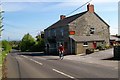
Rose and Portcullis
A stone built pub in Butleigh typical of the area. Find out more at http://www.roseandportcullis.co.uk/
Image: © Glyn Baker
Taken: 7 May 2006
0.14 miles
6
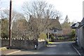
Water Lane, Butleigh
One of the thatched houses in the village.
Image: © Richard Webb
Taken: 6 Apr 2015
0.14 miles
7

Direction Sign - Signpost opposite the Rose and Portcullis public house in Butleigh
Pyramid finial - 2 arms; Somerset SCC pyramid by the UC road, in parish of Butleigh (Mendip District), diagonally opposite the Rose and Portcullis public house on the northwest side of the crossroads of Sub Road, Barton Road and Wood Lane.
surveyed
Milestone Society National ID: SO_ST5133A
Image: © Milestone Society
Taken: Unknown
0.15 miles
8
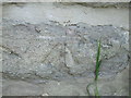
Benchmark on the Rose and Portcullis
A faint but legible cutmark on the pub at the crossroads of Sub Road and Barton Road. See https://www.bench-marks.org.uk/bm129649 for the entry in the Benchmark Database and Image] for a wider look at the pub.
Image: © Neil Owen
Taken: 12 Jul 2020
0.16 miles
9
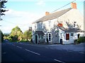
The Rose and Portcullis
Village inn built of local stone.
Image: © Maigheach-gheal
Taken: 20 Sep 2009
0.16 miles
10

Diverted to the pub
The Rose and Portcullis from Barton Road and it seems there is a good reason to wander by. A benchmark dating from the nineteenth century can still be made out on the wall below the Stop sign - see Image
Image: © Neil Owen
Taken: 12 Jul 2020
0.16 miles