IMAGES TAKEN NEAR TO
Burgess Lane, GLASTONBURY, BA6 8RF
Introduction
This page details the photographs taken nearby to Burgess Lane, BA6 8RF by members of the Geograph project.
The Geograph project started in 2005 with the aim of publishing, organising and preserving representative images for every square kilometre of Great Britain, Ireland and the Isle of Man.

There are currently over 7.5m images from over14,400 individuals and you can help contribute to the project by visiting https://www.geograph.org.uk
Image Map
Images are licensed for reuse under creativecommons.org/licenses/by-sa/2.0
Notes
- Clicking on the map will re-center to the selected point.
- The higher the marker number, the further away the image location is from the centre of the postcode.
Image Listing (7 Images Found)
Images are licensed for reuse under creativecommons.org/licenses/by-sa/2.0
Image
Details
Distance
1
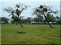
Christmas Mistletoe
A traditional apple orchard in the heart of Somerset.
Image: © Patrick Mackie
Taken: 24 Dec 2005
0.09 miles
4
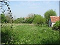
Small field, West Town
A lovely piece of wildness off Tucker's Lane.
Image: © Richard Webb
Taken: 21 Apr 2011
0.16 miles
5
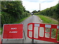
Lane closed for road works at Baltonsborough
Image: © Rob Purvis
Taken: 11 Jun 2014
0.18 miles
6
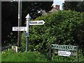
Signpost, Tucker's Lane
A Somerset County Council (before the north was hived off) fingerpost in Baltonsborough.
Image: © Richard Webb
Taken: 21 Apr 2011
0.23 miles
7
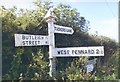
Direction Sign - Signpost on Tucker's Lane
Pyramid finial - 3 arms (2 missing); Somerset SCC pyramid (missing) by the UC road, in parish of Baltonsborough (Mendip District), on the west side of the T junction of junction of Tucker's Lane and Church Lane.
surveyed
Milestone Society National ID: SO_ST5334
Image: © A Riley
Taken: Unknown
0.24 miles