IMAGES TAKEN NEAR TO
Martin Street, GLASTONBURY, BA6 8QU
Introduction
This page details the photographs taken nearby to Martin Street, BA6 8QU by members of the Geograph project.
The Geograph project started in 2005 with the aim of publishing, organising and preserving representative images for every square kilometre of Great Britain, Ireland and the Isle of Man.

There are currently over 7.5m images from over14,400 individuals and you can help contribute to the project by visiting https://www.geograph.org.uk
Image Map
Images are licensed for reuse under creativecommons.org/licenses/by-sa/2.0
Notes
- Clicking on the map will re-center to the selected point.
- The higher the marker number, the further away the image location is from the centre of the postcode.
Image Listing (10 Images Found)
Images are licensed for reuse under creativecommons.org/licenses/by-sa/2.0
Image
Details
Distance
1

Ordnance Survey Cut Mark
This damaged OS cut mark can be found on the SW face, south angle of the farmhouse to the east of the road. It once marked a point 19.404m above mean sea level.
Image: © Adrian Dust
Taken: 21 Nov 2014
0.02 miles
2
Grassland near Baltonsborough
The thirty mph speed limit signs can just be seen on Martin Street on the southern edge of Baltonsborough.
Image: © Richard Webb
Taken: 21 Apr 2011
0.15 miles
3
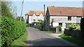
Martin Street, Baltonsborough
Looking towards the village centre past St Anne's.
Image: © Richard Webb
Taken: 21 Apr 2011
0.16 miles
4

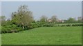
Grassland near Baltonsborough
Not so many hedgerow trees now, the long lost elms were never replaced.
Image: © Richard Webb
Taken: 21 Apr 2011
0.18 miles

6

Stonework, St Anne's
A rather imposing 19th century building, St Anne's was a nunnery school before becoming a boarding house for Millfield School. This panel is above a doorway opening on to Martin Street.
Image: © Richard Webb
Taken: 21 Apr 2011
0.20 miles
7
Gate near Catsham
An access route to the River Brue. The water is closed, it is now the coarse fishing close season.
Image: © Richard Webb
Taken: 21 Apr 2011
0.22 miles
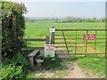
9

Stile near Catsham
A path cuts the acute angle between two lanes. Almost all the farmland here is under grass. Dairy farming was important here when I lived in the area and probably still is.
Image: © Richard Webb
Taken: 21 Apr 2011
0.22 miles
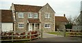
10

Gate to field south of Ham Street
Image: © Sarah Charlesworth
Taken: 16 Jun 2011
0.24 miles