IMAGES TAKEN NEAR TO
Kingweston Road, GLASTONBURY, BA6 8FL
Introduction
This page details the photographs taken nearby to Kingweston Road, BA6 8FL by members of the Geograph project.
The Geograph project started in 2005 with the aim of publishing, organising and preserving representative images for every square kilometre of Great Britain, Ireland and the Isle of Man.

There are currently over 7.5m images from over14,400 individuals and you can help contribute to the project by visiting https://www.geograph.org.uk
Image Map
Images are licensed for reuse under creativecommons.org/licenses/by-sa/2.0
Notes
- Clicking on the map will re-center to the selected point.
- The higher the marker number, the further away the image location is from the centre of the postcode.
Image Listing (17 Images Found)
Images are licensed for reuse under creativecommons.org/licenses/by-sa/2.0
Image
Details
Distance
1
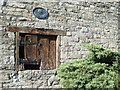
Rood farm
With a little wooden door in not so rude health.
Image: © Neil Owen
Taken: 12 Jul 2020
0.06 miles
2
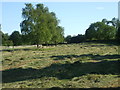
The path up Butleigh Hill
A little mowing gives a more inviting appeal.
Image: © Neil Owen
Taken: 12 Jul 2020
0.07 miles
3
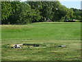
A home hole
A large back garden is just the place to create your own golf course, even if it's just the one hole.
Image: © Neil Owen
Taken: 12 Jul 2020
0.07 miles
4
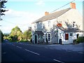
The Rose and Portcullis
Village inn built of local stone.
Image: © Maigheach-gheal
Taken: 20 Sep 2009
0.09 miles
5
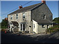
The Rose and Portcullis in Butleigh
The pub stands on the crossroads just to the south of the village. Back in the distant past, the area was rich in cider apples and hence there were two main pubs in the village for many years. One is now lost but the other was the New Inn, which became the Rose and Portcullis in 1860 - thought to be a unique name in the country.
In 1901 the Rose and Portcullis was leased by The People’s Refreshment-House Association, whose aim was to encourage the sale of food and non-intoxicating drinks. By placing an emphasis away from alcohol, the landlords were charged to “regard themselves as an agent of temperance and good behaviour”. The Association carried on into WWII, but the pub now has a more traditional stance.
Image: © Neil Owen
Taken: 12 Jul 2020
0.09 miles
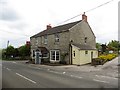
6

Diverted to the pub
The Rose and Portcullis from Barton Road and it seems there is a good reason to wander by. A benchmark dating from the nineteenth century can still be made out on the wall below the Stop sign - see Image
Image: © Neil Owen
Taken: 12 Jul 2020
0.09 miles
8
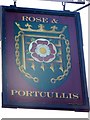
Sign for the Rose and Portcullus
A portcullis is the framed metal gate at the entrance to a castle which could be lowered quickly on chains as a defence. 'Portcullis' literally means 'sliding door or gate'. Its distinctive shape, and its symbolic representation of stout defence made it a popular heraldic symbol. It refers heraldically to the Dukes of Beaufort, Henry VII, Henry VIII, and City of Westminster etc. At Butleigh the Tudor rose has been added to the sign.
Image: © Maigheach-gheal
Taken: 20 Sep 2009
0.09 miles
9
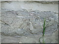
Benchmark on the Rose and Portcullis
A faint but legible cutmark on the pub at the crossroads of Sub Road and Barton Road. See https://www.bench-marks.org.uk/bm129649 for the entry in the Benchmark Database and Image] for a wider look at the pub.
Image: © Neil Owen
Taken: 12 Jul 2020
0.10 miles
10

Direction Sign - Signpost opposite the Rose and Portcullis public house in Butleigh
Pyramid finial - 2 arms; Somerset SCC pyramid by the UC road, in parish of Butleigh (Mendip District), diagonally opposite the Rose and Portcullis public house on the northwest side of the crossroads of Sub Road, Barton Road and Wood Lane.
surveyed
Milestone Society National ID: SO_ST5133A
Image: © Milestone Society
Taken: Unknown
0.11 miles