IMAGES TAKEN NEAR TO
Hooper Avenue, WELLS, BA5 3NA
Introduction
This page details the photographs taken nearby to Hooper Avenue, BA5 3NA by members of the Geograph project.
The Geograph project started in 2005 with the aim of publishing, organising and preserving representative images for every square kilometre of Great Britain, Ireland and the Isle of Man.

There are currently over 7.5m images from over14,400 individuals and you can help contribute to the project by visiting https://www.geograph.org.uk
Image Map
Images are licensed for reuse under creativecommons.org/licenses/by-sa/2.0
Notes
- Clicking on the map will re-center to the selected point.
- The higher the marker number, the further away the image location is from the centre of the postcode.
Image Listing (26 Images Found)
Images are licensed for reuse under creativecommons.org/licenses/by-sa/2.0
Image
Details
Distance
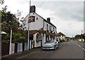
2
The Britannia Inn, Wells
The inn was built in 1830 and at that time was a pub on a lonely stretch of road in the countryside. Modern Wells encroached in the post-war period.
Image: © Neil Owen
Taken: 26 May 2021
0.04 miles
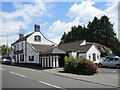
3
Wells, The Britannia Inn
Pub on Bath Road. Internally, split rectangular bar, with drinking areas to left & right & dining room at back. Cask ales on offer at my visit: Wadworth 6X, Butcombe Bitter, Courage Best.
Image: © Mike Faherty
Taken: 12 Apr 2009
0.04 miles
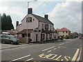
4
Entrance to Hooper Avenue
The road sign has some additional dedication to a former Bishop of the city. See Image] for a closer look.
Image: © Neil Owen
Taken: 26 May 2021
0.05 miles
5
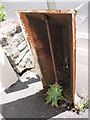
Hollow and with a weed growing
The reverse of the cast iron milepost on the Bath Road as it leaves Wells. See Image] for a frontal look.
Image: © Neil Owen
Taken: 26 May 2021
0.05 miles
6

Milepost on the Bath Road
The B3139 leaves Wells and heads east towards Bath. In what is now a modern housing area there stands a milepost one mile from the city - a typical cast iron turnpike version. See Image] for what lies behind it.
Image: © Neil Owen
Taken: 26 May 2021
0.05 miles
7

Wells, milepost
Cast-iron milepost on Bath Road; V-shaped with bevel. Legend on this side reads "BATH/19/MILES"; on the other, "WELLS/1/MILE". English Heritage-listed http://www.imagesofengland.org.uk/Details/default.aspx?pid=2&id=483258
Image: © Mike Faherty
Taken: 12 Apr 2009
0.05 miles
8
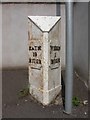
Old Milepost by the B3139, Bath Road, Wells
Metal post with attached metal plate by the B3139, in parish of Wells (Mendip District), Bath Road, 160m East of Churchill Road, on pavement in front of garden wall (stone), beside Bus Stop, on North side of road. Plated iron casting, erected by the Wells turnpike trust in the 19th century.
Inscription reads:-
: BATH / 19 / MILES : : WELLS / 1 / MILE :
Grade II listed.
List Entry Number: 1382872 https://historicengland.org.uk/listing/the-list/list-entry/1382872
Milestone Society National ID: SO_BAWL19
Image: © Mike Faherty
Taken: 12 Apr 2009
0.06 miles
9
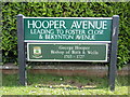
Hooper Avenue
It is appropriate that the city of Wells marks one of its notable clergymen. Hooper was born in 1640 at Grimley, Worcestershire, and had a long career in the English High Church, ending his days as Bishop here. See Image] for a contextual view of the post-war road.
Image: © Neil Owen
Taken: 26 May 2021
0.06 miles
10
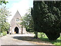
An old cemetery with a sad tale
A mortuary chapel stands in a now-closed cemetery in the south-eastern suburbs of modern Wells. Lands were purchased from a local owner and set aside for burial services. It was blessed in 1874, expanded in 1921 and finally closed in 1963. Originally it was set in a secluded and wooded valley, far from the city. However, as is the nature of things, the area around it was swallowed up as part of the expansion and many houses now surround it.
The tale of this burial ground is that it was associated with the building the Somerset and Bath Lunatic Asylum just up the road near South Horrington. Some 2,900 poor souls now rest here.
The site was turned over to the fledgling National Health Service in 1948 and remained for some time. For a period in the 1990s it was looked after by the Somerset Trust for Nature Conservation, but work ended in 1997. Later, the news broke that the cemetery was to be sold off at auction; a major appeal circumvented the plan to build more houses here. Today the old cemetery is cared for by a volunteer group, which includes some wood sculptures in the grounds.
Image: © Neil Owen
Taken: 26 May 2021
0.07 miles