IMAGES TAKEN NEAR TO
St. Thomas Terrace, WELLS, BA5 2XG
Introduction
This page details the photographs taken nearby to St. Thomas Terrace, BA5 2XG by members of the Geograph project.
The Geograph project started in 2005 with the aim of publishing, organising and preserving representative images for every square kilometre of Great Britain, Ireland and the Isle of Man.

There are currently over 7.5m images from over14,400 individuals and you can help contribute to the project by visiting https://www.geograph.org.uk
Image Map (Loading...)


Getting Data...Please wait
Leaflet Map data © OpenStreetMap
Images are licensed for reuse under creativecommons.org/licenses/by-sa/2.0
Notes
- Clicking on the map will re-center to the selected point.
- The higher the marker number, the further away the image location is from the centre of the postcode.
Image Listing (107 Images Found)
Images are licensed for reuse under creativecommons.org/licenses/by-sa/2.0
Image
Details
Distance
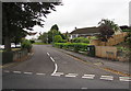
1
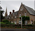
St Thomas Terrace, Wells
The North Street side of a row of mid Victorian houses extending to St Thomas Street.
Dating from c1860, grade II listed in 1988. The Church of St Thomas spire is in the background.
Image: © Jaggery
Taken: 27 Sep 2016
0.00 miles
2
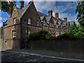
St Thomas Terrace, Wells
Built as a memorial to Richard Jenkyns, dean of Wells and designed, like neighbouring St Thomas' church, by the architect S S Teulon.
Image: © Chris Brown
Taken: 9 Jul 2019
0.00 miles
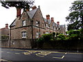
3

St Thomas' Terrace, Wells
Grade II listed. Listing number 1383156. Row of cottages. c1860, by SS Teulon, for the Revd George Blissett.
Image: © Andrew Abbott
Taken: 20 Sep 2015
0.01 miles
4
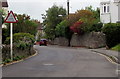
Non-standard warning sign, North Road, Wells
The sign shows SLOW PLEASE! Concealed Exit 20 yds.
Image: © Jaggery
Taken: 27 Sep 2016
0.01 miles
5
St Thomas Terrace, Wells
The St Thomas Street side of a row of mid Victorian houses extending to North Street.
The terrace dates from c1860, grade II listed in 1988.
Image: © Jaggery
Taken: 27 Sep 2016
0.01 miles
6
North Road, Wells
Viewed across the B3139 Bath Road.
Image: © Jaggery
Taken: 27 Sep 2016
0.01 miles
7
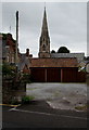
Three lockup garages and a church spire, Wells
The garages are set back from the south side of North Road
The Church of St Thomas spire is 60 metres behind the garages.
Image: © Jaggery
Taken: 27 Sep 2016
0.01 miles
8
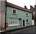
Old Post Office, Wells
Viewed across St Thomas Street. The postbox http://www.geograph.org.uk/photo/5139114 in the wall of the Old Post Office remains in use.
Image: © Jaggery
Taken: 27 Sep 2016
0.02 miles
9
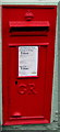
King George V postbox in the wall of the Old Post Office, Wells
Located here. http://www.geograph.org.uk/photo/5139110 The GR on the box is short for Georgius Rex,
Latin for King George, in this case King George V
who reigned from May 1910-January 1936.
Image: © Jaggery
Taken: 27 Sep 2016
0.02 miles
10

Two street names commemorating former mayors, Wells
On the corner of Kippax Avenue and North Road. Kippax Avenue was named in memory of Ernald de M Kippax, Mayor of Wells 1949-1951. Teagle Close was named in memory of Harold Teagle, Mayor of Wells 1965-1966.
Image: © Jaggery
Taken: 27 Sep 2016
0.02 miles