
IMAGES TAKEN NEAR TO
Portway Avenue, WELLS, BA5 2QF
Introduction
This page details the photographs taken nearby to Portway Avenue, BA5 2QF by members of the Geograph project.
The Geograph project started in 2005 with the aim of publishing, organising and preserving representative images for every square kilometre of Great Britain, Ireland and the Isle of Man.

There are currently over 7.5m images from over14,400 individuals and you can help contribute to the project by visiting https://www.geograph.org.uk
Image Map
Images are licensed for reuse under creativecommons.org/licenses/by-sa/2.0
Notes
- Clicking on the map will re-center to the selected point.
- The higher the marker number, the further away the image location is from the centre of the postcode.
Image Listing (362 Images Found)
Images are licensed for reuse under creativecommons.org/licenses/by-sa/2.0
Image
Details
Distance
1
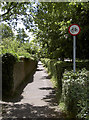
Lovers' Walk
This is an old lane that used to run from the old Blue School to Mountery Road; today it remains a fairly sheltered passage except where the newer Whiting Way cuts through it at the junction here.
Image: © Neil Owen
Taken: 24 Jun 2014
0.02 miles
2
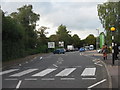
Whiting Way, Wells
Looking north past the entrance to Waitrose and a public car park, with the junction with Mountery Road beyond.
Image: © M J Richardson
Taken: 30 Oct 2013
0.04 miles
3

Portway Building, Wells
Wells Learning Centre is based in this curious building dating from 1900 (though Pevsner gives 1898) and 1913, on the corner of Portway (left) and Portway Avenue. It was built as a girls' school, and has a central wooden cupola and an octagonal turret surmounted by a lead finial. Pevsner, in the 1958 edition of "North Somerset and Bristol", describes this as "quite a pretty example of the freedom from imitation of the past which was then current amongst the brighter architects".
Image: © Derek Harper
Taken: 8 Mar 2010
0.05 miles
4
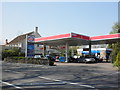
Esso Service Station, Chamberlain Street, Wells
Image: © Roger Cornfoot
Taken: 23 Apr 2010
0.05 miles
5

New shops
The old car park In Whiting Way is now being developed as new Waitrose. Parking will still be allowed but those not shopping will still have to pay for the privilege. See Image] for another view of the works.
Image: © Neil Owen
Taken: 4 Jul 2013
0.05 miles
6

Waiting for Waitrose
The new shop development in Whiting Way, planned to open very soon. See Image] for another view of the old car park.
Image: © Neil Owen
Taken: 4 Jul 2013
0.05 miles
7
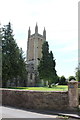
St Cuthbert's Church (1)
This photograph Image shows a view of a street in Wells.
Image: © Chris' Buet
Taken: 7 Aug 2014
0.05 miles
8

Wells : Esso Petrol Station
Looking towards an Esso petrol station on Chamberlain Street.
Image: © Lewis Clarke
Taken: 22 Jul 2015
0.06 miles
9

Fresh this year!
The new Waitrose supermarket on what was a car park. It opened in July 2013.
Image: © Neil Owen
Taken: 24 Jun 2014
0.06 miles
10

Wells : Waitrose
A Waitrose shop off Whiting Way.
Image: © Lewis Clarke
Taken: 19 Jun 2023
0.06 miles