IMAGES TAKEN NEAR TO
Melbourne House Mews, WELLS, BA5 2PG
Introduction
This page details the photographs taken nearby to Melbourne House Mews, BA5 2PG by members of the Geograph project.
The Geograph project started in 2005 with the aim of publishing, organising and preserving representative images for every square kilometre of Great Britain, Ireland and the Isle of Man.

There are currently over 7.5m images from over14,400 individuals and you can help contribute to the project by visiting https://www.geograph.org.uk
Image Map (Loading...)


Getting Data...Please wait
Leaflet Map data © OpenStreetMap
Images are licensed for reuse under creativecommons.org/licenses/by-sa/2.0
Notes
- Clicking on the map will re-center to the selected point.
- The higher the marker number, the further away the image location is from the centre of the postcode.
Image Listing (866 Images Found)
Images are licensed for reuse under creativecommons.org/licenses/by-sa/2.0
Image
Details
Distance
1
![Wells houses [34]](https://s2.geograph.org.uk/geophotos/06/33/50/6335098_08809f43_120x120.jpg)
Wells houses [34]
Melbourne House is late 18th century and is now used as offices. Some fine original features survive. Listed, grade II, with details at: https://historicengland.org.uk/listing/the-list/list-entry/1382937
A Roman settlement around three wells that became much more important when the Anglo-Saxon King Ine of Wessex founded a minster church in 704, Wells is the second smallest city in England.
Image: © Michael Dibb
Taken: 23 Aug 2019
0.04 miles
2

Skateboard park in Wells
Sandwiched between the A39 and the Waitrose car park.
Image: © Bill Boaden
Taken: 30 Dec 2016
0.05 miles
3
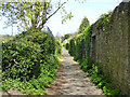
Lovers Walk, Wells
A public footpath towards New Street.
Image: © Robin Webster
Taken: 15 Apr 2017
0.06 miles
4

Skateboard park, Wells
With Waitrose car park behind.
Image: © Tim Heaton
Taken: 10 Feb 2015
0.06 miles
5
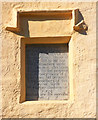
Wall plaque Harpers Almshouses, Chamberlain Street - Wells
Inset into the front wall of Harpers Almshouses is this wall plaque with its inscription describing the endowment.
Image: © Mike Searle
Taken: 28 Sep 2008
0.06 miles
6

Melbourne House Mews, Wells, Somerset
The buildings include a Business Centre.
Image: © Ruth Sharville
Taken: 13 Jan 2022
0.06 miles
7
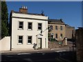
House on Chamberlain Street, Wells
The early C19 house http://webapp1.somerset.gov.uk/her/details.asp?prn=20344 is opposite the entrance to a car park. Set back from the street on the right is a 5-bay C18 house http://webapp1.somerset.gov.uk/her/details.asp?prn=20343 .
Image: © Derek Harper
Taken: 17 Jun 2010
0.06 miles
8

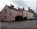
Chamberlain Street, Wells
A view along Chamberlain St, Wells. The wall in the picture also has an Ordnance Survey bench mark.
Image
Image: © V1ncenze
Taken: 6 Aug 2021
0.06 miles
9

Ordnance Survey Bench Mark
This mark is located on a wall at 35 Chamberlain Street, Wells. These marks were used by Ordnance Survey for mapping purposes.
Image
Image: © V1ncenze
Taken: 6 Aug 2021
0.06 miles
10
Chamberlain Street houses, Wells
Southwest of the Union Street http://www.geograph.org.uk/photo/5134431 junction on the left.
Image: © Jaggery
Taken: 27 Sep 2016
0.06 miles