IMAGES TAKEN NEAR TO
Portway, WELLS, BA5 2BW
Introduction
This page details the photographs taken nearby to Portway, BA5 2BW by members of the Geograph project.
The Geograph project started in 2005 with the aim of publishing, organising and preserving representative images for every square kilometre of Great Britain, Ireland and the Isle of Man.

There are currently over 7.5m images from over14,400 individuals and you can help contribute to the project by visiting https://www.geograph.org.uk
Image Map (Loading...)


Getting Data...Please wait
Leaflet Map data © OpenStreetMap
Images are licensed for reuse under creativecommons.org/licenses/by-sa/2.0
Notes
- Clicking on the map will re-center to the selected point.
- The higher the marker number, the further away the image location is from the centre of the postcode.
Image Listing (16 Images Found)
Images are licensed for reuse under creativecommons.org/licenses/by-sa/2.0
Image
Details
Distance

2
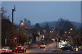
The junction of Mountery Road and Strawberry Way
An important junction for through traffic in Wells, being the meeting of the A371 and the A39. The cathedral can be seen ahead.
Image: © Bill Boaden
Taken: 30 Dec 2016
0.11 miles
3
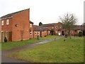
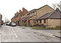
Housing on Lethbridge Road, Wells
Forming a little quadrangle of eight connected properties at the point where footpath WS 17/37 heads off towards Wells Leisure Centre.
Image: © Derek Harper
Taken: 22 Feb 2010
0.15 miles
4
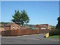
Charter Way, Wells
Part of a modern estate north of the A371, Portway
Image: © David Smith
Taken: 28 Sep 2011
0.16 miles
5
Charter Way, Wells
Part of a modern estate on the west of Wells
Image: © David Smith
Taken: 28 Sep 2011
0.17 miles
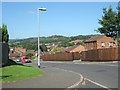
6
Wookey Hole Road, Wells
New housing by the junction with Singleton Court on the right, followed by a Victorian red brick terrace. Hidden on the left is the junction with Ash Lane.
Image: © Derek Harper
Taken: 22 Feb 2010
0.21 miles
7

Portway Building, Wells
Wells Learning Centre is based in this curious building dating from 1900 (though Pevsner gives 1898) and 1913, on the corner of Portway (left) and Portway Avenue. It was built as a girls' school, and has a central wooden cupola and an octagonal turret surmounted by a lead finial. Pevsner, in the 1958 edition of "North Somerset and Bristol", describes this as "quite a pretty example of the freedom from imitation of the past which was then current amongst the brighter architects".
Image: © Derek Harper
Taken: 8 Mar 2010
0.21 miles
8
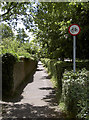
Lovers' Walk
This is an old lane that used to run from the old Blue School to Mountery Road; today it remains a fairly sheltered passage except where the newer Whiting Way cuts through it at the junction here.
Image: © Neil Owen
Taken: 24 Jun 2014
0.22 miles
9
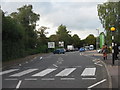
Whiting Way, Wells
Looking north past the entrance to Waitrose and a public car park, with the junction with Mountery Road beyond.
Image: © M J Richardson
Taken: 30 Oct 2013
0.23 miles
10
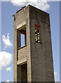
Top of the tower
Wells fire station's tower. See Image] for the rest of the station.
Image: © Neil Owen
Taken: 24 Jun 2014
0.23 miles