IMAGES TAKEN NEAR TO
High Street, WELLS, BA5 2AG
Introduction
This page details the photographs taken nearby to High Street, BA5 2AG by members of the Geograph project.
The Geograph project started in 2005 with the aim of publishing, organising and preserving representative images for every square kilometre of Great Britain, Ireland and the Isle of Man.

There are currently over 7.5m images from over14,400 individuals and you can help contribute to the project by visiting https://www.geograph.org.uk
Image Map
Images are licensed for reuse under creativecommons.org/licenses/by-sa/2.0
Notes
- Clicking on the map will re-center to the selected point.
- The higher the marker number, the further away the image location is from the centre of the postcode.
Image Listing (1065 Images Found)
Images are licensed for reuse under creativecommons.org/licenses/by-sa/2.0
Image
Details
Distance
1
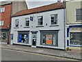
High Street Shops, Wells
A couple of shops located on High Street, Wells. The shop to the right has an Ordnance Survey bench mark.
Image
Image: © V1ncenze
Taken: 6 Aug 2021
0.01 miles
2
Gas bottles, Wells
A bright blue line along the pavement outside a hardware store on the High Street in Wells.
Image: © Derek Harper
Taken: 8 Mar 2010
0.01 miles
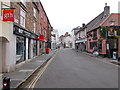
3
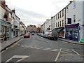
Corner of Queen Street
Looking towards the City Centre.
Image: © Des Blenkinsopp
Taken: 22 Aug 2014
0.01 miles
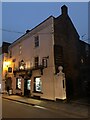
4
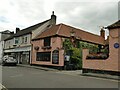
The City Arms, High Street frontage
The building has a complex history, Historic England describe it as of 16th century origin but the blue plaque to the right says there were earlier buildings from 1427. The same plaque says it was a gaol from 1506 but that it was an inn by 1639 and has remained so. HE however say it remained a gaol until 1800. Both may be true as it was not unknown for an inn to serve as a bridewell or temporary gaol. Parts are modern rebuild after a fire. See the Historic England listing for a fuller history (grade II, list entry 1382996).
Image: © Stephen Craven
Taken: 15 Jul 2021
0.01 miles
5
Ordnance Survey Bench Mark
This mark is located on a shop at 66 High Street, Wells. These marks were used by Ordnance Survey for mapping purposes.
Image
Image: © V1ncenze
Taken: 6 Aug 2021
0.01 miles
6
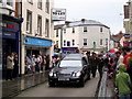
Harry Patch's funeral procession
The funeral procession of Harry Patch 'the last British Tommy' as it makes its way up Wells High Street.
Image: © Sharon Loxton
Taken: 6 Aug 2009
0.01 miles
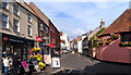
8
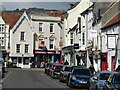
Wells - Broad Street
Commercial street in Wells' bustling town centre.
www.wellssomerset.com
Image: © Colin Smith
Taken: 31 Mar 2022
0.01 miles
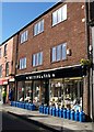
9
Minsky's barber shop, Wells
8 Broad Street is Grade II listed, see https://historicengland.org.uk/listing/the-list/list-entry/1382882
Part of the development which took place when Broad Street (formerly Wette or Water Lane) was widened between 1835-1849.
Image: © Jonathan Hutchins
Taken: 16 Nov 2018
0.01 miles
10
High Street - viewed from Queen Street
Image: © Betty Longbottom
Taken: 7 Jun 2016
0.01 miles