IMAGES TAKEN NEAR TO
Rowdens Road, WELLS, BA5 1TU
Introduction
This page details the photographs taken nearby to Rowdens Road, BA5 1TU by members of the Geograph project.
The Geograph project started in 2005 with the aim of publishing, organising and preserving representative images for every square kilometre of Great Britain, Ireland and the Isle of Man.

There are currently over 7.5m images from over14,400 individuals and you can help contribute to the project by visiting https://www.geograph.org.uk
Image Map
Images are licensed for reuse under creativecommons.org/licenses/by-sa/2.0
Notes
- Clicking on the map will re-center to the selected point.
- The higher the marker number, the further away the image location is from the centre of the postcode.
Image Listing (90 Images Found)
Images are licensed for reuse under creativecommons.org/licenses/by-sa/2.0
Image
Details
Distance
1
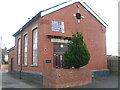
The Old Pumphouse
Although now converted into business use, the pumphouse is not that old.
Image: © Neil Owen
Taken: 14 Dec 2022
0.02 miles
2
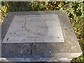
Plaque by East Somerset Way, Wells
The plaque Image] commemorates the history of railways in Wells from 1859 to 1969
Image: © David Smith
Taken: 17 Nov 2017
0.03 miles
3
Plaque for the history of railways in Wells
On the site of Wells East station
Image: © David Smith
Taken: 17 Nov 2017
0.03 miles
4
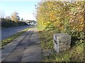
Wells : East Somerset Way A371
The East Somerset Way heading out of Wells towards Shepton Mallet.
Image: © Lewis Clarke
Taken: 15 Jun 2012
0.04 miles
5
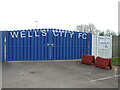
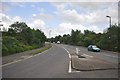
Home of Wells City F.C.
The club formed in the summer of 1890 and moved to the current home in Rowdens Road in 1893/94 season.
Image: © Neil Owen
Taken: 14 Dec 2022
0.04 miles
6
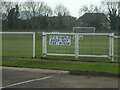
Simple game, football
A simple sign on the ground.
Image: © Neil Owen
Taken: 14 Dec 2022
0.05 miles
7

Gates to Wells recreation ground
Mary Bignal-Rand was a Wells girl who represented Great Britain in the 1960 and 1964 Olympics in the long jump, winning gold in the latter. Her name is given over to the gates of the recreation ground, which a small plaque records as being refurbished in 2012.
Image: © Neil Owen
Taken: 14 Dec 2022
0.05 miles
8
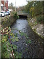
The Keward Brook from Rowden Road bridge
The brook flows from the Bishop's Palace and out to the southwest of the city.
Image: © Neil Owen
Taken: 14 Dec 2022
0.06 miles
9
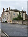
Sherston Hotel, Southover, Wells
The Sherston Hotel, Southover, Wells. This hotel also has an Ordnance Survey bench mark.
Image
Image: © V1ncenze
Taken: 8 Aug 2021
0.07 miles
10
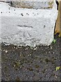
Ordnance Survey Bench Mark
This mark is located on a wall at the Sherston Hotel, Southover, Wells. These marks were used by Ordnance Survey for mapping purposes
Image
Image: © V1ncenze
Taken: 8 Aug 2021
0.07 miles