
IMAGES TAKEN NEAR TO
Glastonbury Road, WELLS, BA5 1TJ
Introduction
This page details the photographs taken nearby to Glastonbury Road, BA5 1TJ by members of the Geograph project.
The Geograph project started in 2005 with the aim of publishing, organising and preserving representative images for every square kilometre of Great Britain, Ireland and the Isle of Man.

There are currently over 7.5m images from over14,400 individuals and you can help contribute to the project by visiting https://www.geograph.org.uk
Image Map
Images are licensed for reuse under creativecommons.org/licenses/by-sa/2.0
Notes
- Clicking on the map will re-center to the selected point.
- The higher the marker number, the further away the image location is from the centre of the postcode.
Image Listing (49 Images Found)
Images are licensed for reuse under creativecommons.org/licenses/by-sa/2.0
Image
Details
Distance
1
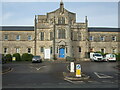
Changing face of an institution
Today this building is part of the Priory hospital and the N.H.S. However, its history has a darker beginning: it was the Union Workhouse.
Designed by S.T. Welch in a Tudor style it was opened in 1825, enlarged in 1871.
Image: © Neil Owen
Taken: 14 Dec 2022
0.01 miles
3

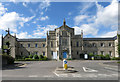
The cop shop is shut
Wells grand police station has been closed and the officers relocated to the fire station a little way up the road as of 2021.
Image: © Neil Owen
Taken: 14 Dec 2022
0.06 miles
4

The former police station
Wells police station on Glastonbury Road was a large and expansive creation built in the 1950s. However, moving with the times it became clear that it was too big and impractical to remain here and so is on the market. The police merged with the fire station offices in Burcott Road in April, 2021, leaving this site up for grabs.
Image: © Neil Owen
Taken: 14 Dec 2022
0.07 miles
5
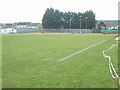
Wells recreation ground
Looking over the pitches to the tennis courts. In earlier times there was a dairy factory behind them.
Image: © Neil Owen
Taken: 14 Dec 2022
0.09 miles
6

Gates to Wells recreation ground
Mary Bignal-Rand was a Wells girl who represented Great Britain in the 1960 and 1964 Olympics in the long jump, winning gold in the latter. Her name is given over to the gates of the recreation ground, which a small plaque records as being refurbished in 2012.
Image: © Neil Owen
Taken: 14 Dec 2022
0.10 miles
7
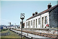
Priory Road Station, Wells
Although England's smallest city, Wells had 2 railway stations less than a quarter of a mile apart. The Great Western line from Yatton to Witham had a station at Tucker Street. This station (which the GW trains passed through without stopping) was the end of the Somerset and Dorset branch from Glastonbury. At the far end of the station the route to Tucker Street bears right, to Glastonbury (only a siding when the picture was taken) left.
Image: © John Thorn
Taken: Unknown
0.10 miles
8
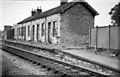
Priory Road Railway Station, Wells
Priory Road station, the terminus of the Somerset & Dorset Jt. Rly. branch line from Glastonbury, closed to all traffic as long ago as 1951, yet the track running past its platform still seems used. The track is in fact that of the GWR's Yatton - Witham line which had closed to passengers 2 years previously in September 1963, but which would remain open through Wells for freight traffic until 1969. Priory Road station did originally have an overall roof spanning the single track but this was removed in 1955.
Image: © Martin Tester
Taken: 17 Aug 1965
0.11 miles
9
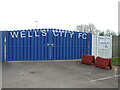
Home of Wells City F.C.
The club formed in the summer of 1890 and moved to the current home in Rowdens Road in 1893/94 season.
Image: © Neil Owen
Taken: 14 Dec 2022
0.11 miles
10
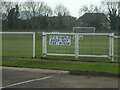
Simple game, football
A simple sign on the ground.
Image: © Neil Owen
Taken: 14 Dec 2022
0.12 miles