
IMAGES TAKEN NEAR TO
Shady Lane, WELLS, BA5 1BN
Introduction
This page details the photographs taken nearby to Shady Lane, BA5 1BN by members of the Geograph project.
The Geograph project started in 2005 with the aim of publishing, organising and preserving representative images for every square kilometre of Great Britain, Ireland and the Isle of Man.

There are currently over 7.5m images from over14,400 individuals and you can help contribute to the project by visiting https://www.geograph.org.uk
Image Map
Images are licensed for reuse under creativecommons.org/licenses/by-sa/2.0
Notes
- Clicking on the map will re-center to the selected point.
- The higher the marker number, the further away the image location is from the centre of the postcode.
Image Listing (22 Images Found)
Images are licensed for reuse under creativecommons.org/licenses/by-sa/2.0
Image
Details
Distance
1

'The Gatehouse'
Formerly a toll house on the Coxley road, this house bears a benchmark on the furthest corner. See Image
Image: © Neil Owen
Taken: 14 Dec 2022
0.03 miles
2
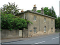
Old Toll House, Keward
Toll House in the parish of Wells, The Gatehouse, (A39) Glastonbury Road.
Grade II listed.
List Entry Number: 1382945 https://historicengland.org.uk/listing/the-list/list-entry/1382945
Surveyed
Milestone Society National ID: SO.WEL02
Image: © Alan Rosevear
Taken: 29 May 2005
0.03 miles
3
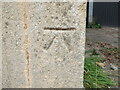
Benchmark on The Gatehouse
A cutmark of nineteenth century vintage on a house along the road to Coxley. See https://www.bench-marks.org.uk/bm152520 for the entry in the Benchmark Database and Image] for a wider look.
Image: © Neil Owen
Taken: 14 Dec 2022
0.04 miles
4
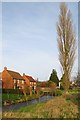
Keward Brook
The Keward Brook runs through Wells and then heads off west to join the River Sheppey and eventually flow across the Somerset Levels.
Image: © Sharon Loxton
Taken: 26 Jan 2008
0.06 miles
5
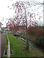
Berries by the Keward Brook
A modern housing development surrounds the brook and some berry-laden trees have been planted.
Image: © Neil Owen
Taken: 14 Dec 2022
0.07 miles
6
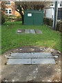
Jocelyn Drive sewage pumping station
A small unit with underground chambers, right beside the Keward Brook. In the last century there was a much bigger seage treatment works a little to the north of the brook, but it has been replaced with modern housing.
Image: © Neil Owen
Taken: 14 Dec 2022
0.08 miles
7
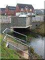
Wand Road bridge
The housing estate is only a few years old and has crossings over the Keward Brook.
Image: © Neil Owen
Taken: 14 Dec 2022
0.08 miles
8

The cop shop is shut
Wells grand police station has been closed and the officers relocated to the fire station a little way up the road as of 2021.
Image: © Neil Owen
Taken: 14 Dec 2022
0.10 miles
9

The former police station
Wells police station on Glastonbury Road was a large and expansive creation built in the 1950s. However, moving with the times it became clear that it was too big and impractical to remain here and so is on the market. The police merged with the fire station offices in Burcott Road in April, 2021, leaving this site up for grabs.
Image: © Neil Owen
Taken: 14 Dec 2022
0.10 miles
10
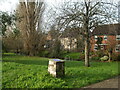
A quiet spot by the brook
Keward Brook flows through this spot close to the south of Wells. Its peaceful nature belies the darker facts. The monument bears a plaque recording the fact that in the seventeenth and eighteenth centuries this was once a place where the guilty would have been hanged, drawn and quartered or burned at the stake.
Image: © Neil Owen
Taken: 14 Dec 2022
0.10 miles